

Latest Weather Blog
Waiting for April to return
Isolated showers and thunderstorms will remain possible through Friday as high temperatures and humidity continue to climb.
THE FORECAST:
Today and Tonight: For Wednesday, expect a partly sunny sky with high temperatures in the mid 80s. It will likely feel a bit sticky. Isolated showers will flare up in the afternoon with rain coverage in the 13 Parish, 3 County forecast area around 20 percent. Any showers should be short-lived but could briefly be heavy. Overnight, activity will taper with low temperatures in the mid 60s.
Trending News
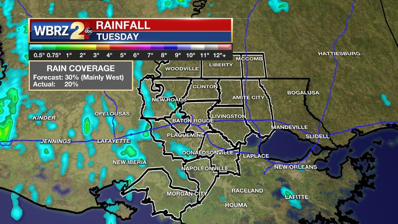
Tuesday’s forecast performed well with only isolated showers during the afternoon hours and that action stayed west of the Mississippi River, as expected. Rain amounts were less than a half an inch.
Up Next: Thursday may offer a slightly better chance at showers across the forecast area but will continue the otherwise partly sunny and warm conditions. On Friday, the shower action will scale back slightly once again and will be very warm with highs in the upper 80s. Into the weekend a strong cold front is expected to pass through. This one will bring showers and thunderstorms but there does not appear to be a severe weather threat at this time. However, afternoon and evening events, such as the LSU spring game, will want to monitor the timing of showers and thunderstorms. As of now, a line of showers and thunderstorms seems more likely which means while an interruption may be expected, a complete washout is not. Then, as skies clear, humidity will break for a few days with temperatures 5-10 degrees below average Sunday into Monday.
THE SCIENCE: A weak upper level trough will remain overhead through today. Some lingering instability will result in isolated showers and thunderstorms flaring up as the sea breeze pushes inland during the peak heat of the day. On Thursday, some weak mid-level forcing will work with diurnal warmth and the marine breeze to once again produce isolated showers and thunderstorms. Friday seems to offer the thinnest spread of showers and thunderstorms through the remainder of the week. As the trough slowly flattens, high temperatures should climb by a degree or two each afternoon through Friday when some locations could top out in the upper 80s. By Saturday, the jet stream will begin digging into the Southeast as a positively tilted trough takes shape. This trough will bring a strong cold front into the area but the orientation does not suggest a threat for severe weather at this time. A line of showers and thunderstorms is currently timed for Saturday Evening with considerably cooler air arriving by Sunday Afternoon. Readings could end up running 5-10 degrees below average Sunday and Sunday Night.
--Josh
More News
