

Latest Weather Blog
Unusual 2016 hurricane season continues with Invest 96L
Newly classified Invest 96L is expected to have a rough transit across the Atlantic Ocean. The National Hurricane Center (NHC) is giving the cluster of showers and thunderstorms a 30 percent chance of further development over the next two days and 40 percent chance by early next week. At this time, the system poses no threat to the United States. An "invest" is designated when a tropical disturbance is being "investigated" by the NHC.
#Invest96L may become infiltrated by dry/stable/dusty Saharan Air, inhibiting development (image via @WeatherBELL) pic.twitter.com/Qc4rPjcxE7
— Greg Postel (@GregPostel) July 28, 2016
While conditions remained moderately favorable on Thursday Morning, dry and stable air is expected to interfere with the system over the next several days. Dr. Greg Postel, hurricane and storm specialist with The Weather Channel, noted this possibility tweeting an image of NASA’s GEOS 5 Atmosphere-Ocean General Circulation Model.
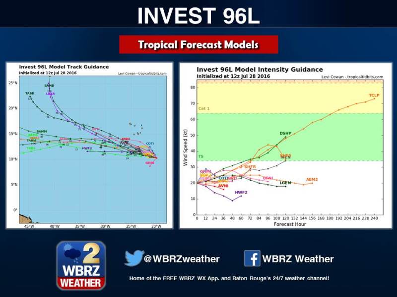
Additional model guidance factors in the harsh conditions, showing a system generally below tropical storm strength as it jogs west-northwest over the weekend. As a reminder, model guidance is simply a tool that supports official forecasts, which should always be given precedence for any weather event.
Invest 96L follows a quiet stretch after the 2016 Hurricane Season got a jump start out of the gates. According to Louisiana State Climatologist Dr. Barry Keim, when Tropical Storm Danielle formed on June 19, it was the earliest fourth named storm in the Atlantic Basin with records dating back to the 1850s. Since then, the pace has slowed. The earliest fifth named storm came on July 23, 2005—a record that now remains intact with regard to present season. The National Hurricane Center shows that five named storms are typically on the board by Late August.
Seasonal hurricane forecasts remain largely unchanged. Both Colorado State Univeristy and the National Oceanic and Atmopsheric Administration (NOAA) are steadfast in calling for near normal acitvity. A normal amount of activity constitutes 12 named storms. While experts can project the number of storms with some accuracy, there is not yet an ability to predict where or when until a system actually forms.
Trending News
Of course, the historical peak of hurricane season comes in Mid-September. Therefore, moving into the month of August, any tropical system will be under close watch along the Atlantic and Gulf Coastlines. Stick with the WBRZ Weather Team online and on social media through the season. Our technology relays advisories and updates from the National Hurricane Center the moment they are issued. For a more detailed look at Invest 96L, check out this briefing from Meteorologist Josh Eachus.
More News
