

Latest Weather Blog
Tuesday PM Forecast: quick line of storms expected Wednesday evening
The next cold front will deliver rain and thunderstorms on Wednesday evening. There will be a brief break of drier weather before a soaking rain moves in this weekend.
Tonight & Tomorrow: Low clouds will thicken overnight as moist, south winds of 5-10mph continue. Some fog could form in nearshore areas, but just low clouds for most inland. Low temperatures will bottom in the upper 60s. Wednesday, some sun will help breed another warm afternoon as high temperatures make it into the upper 70s, even flirting with the 80s in one or two spots. Clouds should increase, especially late in the day as a cold front approaches from the west. A line of rain and thunderstorms is expected to arrive with the front shortly after sunset. There is a shot at one or two gusty thunderstorms, but significant severe weather is not anticipated.
Up Next: By Thursday morning, the line will be east of the Metro Area and sunshine will return for the afternoon. Though not cold, a cooler air mass will follow to end the week with highs in the mid to upper 60s. Clouds will quickly return on Friday as the potential is increasing for a steady, soaking rain on Saturday. That batch of precipitation should start to taper on Sunday, for perhaps a bit of dry time before the weekend is over.
Trending News
Get the latest 7-day forecast and real time weather updates HERE.
Watch live news HERE.
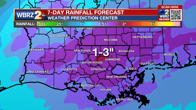
Detailed Forecast: An upper level trough of low pressure will strengthen as it moves across the Mountain West and into the Midwest on Wednesday. A surface low will form in close proximity to the upper level energy and take a similar track which means the best ingredients for severe weather will stay far northwest of the local area. However, the threat for strong thunderstorms will not be zero. Instability will be low to begin with and activity is not expected to develop until aided by the front itself. That will come after sunset and beyond peak daytime warming, further limiting the instability. Wind shear is at the lower limits of what would be needed to support severe weather. Along the line of thunderstorms, it will be possible for some gusty wind and a brief spin up cannot be totally ruled out but that would really be pushing it. The line is expected to reach counties and parishes northwest of Baton Rouge around 7pm and be east of I-55 by about 2am. Skies will clear behind the front with a drier and slightly more seasonably air mass for Thursday and Friday. The front will stall in the Gulf of Mexico and southwest winds in the atmosphere will draw the boundary and moisture back to the north., Expect clouds to increase on Friday and a swath of rain to develop shortly after. A surface low will form close to the tail end of the front near the coast of Texas. As this low is moved from southwest to northeast by the next upper level trough of low pressure, a steady rain is expected to occur for much of Saturday and perhaps into Sunday until the surface low moves east of the local area. A couple of inches of rain could fall in some areas.
--Josh
The Storm Station is here for you, on every platform. Your weather updates can be found on News 2, wbrz.com, and the WBRZ WX App on your Apple or Android device. Follow WBRZ Weather on Facebook and Twitter for even more weather updates while you are on the go.
More News
