

Latest Weather Blog
Tuesday PM Forecast: long, pleasant stretch of weather begins
Much quieter weather is in store for the remainder of the 7-Day Forecast. Temperatures will slowly trend upward from five degrees below average, to five degrees above average.
Next 24 Hours: As the last showers and thunderstorms move east of I-55, skies will clear overnight. South winds will turn west and diminish to 10-15mph. This will help to guide in some cooler air and low temperatures will dip into the upper 40s. Wednesday is shaping up to be the beginning of a stretch of pleasant early spring weather. With nearly full sunshine, high temperatures will make it into the upper 60s with northwest winds of 5-10mph.
Up Next: Thursday morning will begin chilly with low temperatures in the mid 40s. A weak upper level disturbance swinging through the area on Thursday could cause a few clouds to pass through skies, but no excitement will come from that. The day as a whole will be mostly sunny with high temperatures back into the low 70s. Friday morning looks to be the chilliest period of the 7-Day Forecast with low temperatures in the low 40s. Skies are expected to stay clear all the way through the weekend with high temperatures climbing from the low 70s Friday afternoon to the upper 70s Sunday afternoon. The next rain should not come until at least the middle of next week. CLICK HERE for your detailed 7-Day Forecast.
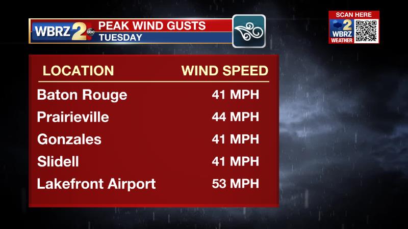
While the severe weather threat passed leaving most of the viewing area unscathed, there were several significant, non-thunderstorm wind gusts on Tuesday that caused some spotty power outages. Here are some of the highest numbers.
Trending News
The Explanation: A cold front and the associated thunderstorms will continue to move east of the area overnight. While the deep upper level trough of low pressure won’t come through right away, we'll notice the effects of the cold front tonight through Thursday. Lows tonight will drop into the upper 40s to middle 50s. Wednesday will be dry and sunny with highs in the lower to upper 60s. While upper level trough starts to swing through on Thursday morning, low temperatures will drop into the low 40s. The lift created by the center of this trough could stir up some mid to high level clouds on Thursday. An upper level ridge of high pressure will remain primarily over the Rockies through the weekend with the atmosphere very slowly warming over the local area. At the surface, high pressure will gradually work eastward from the Plains to east coast of Florida, Friday through Monday. With no significant onshore winds until at least Monday, if that soon, the threat of precipitation will be minimal through Tuesday. At the surface, dry air will keep morning lows on the cool side of average this weekend, roughly 5-8 degrees below normal. Highs will likely to be pretty close to normal through the weekend, then as onshore flow returns on Monday, it should lead to high temperatures moving into the 80s for midweek next week.
The Storm Station is here for you, on every platform. Your weather updates can be found on News 2, wbrz.com, and the WBRZ WX App on your Apple or Android device. Follow WBRZ Weather on Facebook and Twitter for even more weather updates while you are on the go.
More News
