

Latest Weather Blog
Tuesday PM Forecast: front through, pleasant weather for two days
A cold front moved through the area on Tuesday morning sweeping away warmer than average temperatures. Clear skies are expected until the next system arrives on Friday.
Next 24 Hours: With drying northwest winds of 5-10mph, expect clear skies overnight and low temperatures in the mid to upper 40s. Wednesday will be sunny and pleasant with high temperatures in the mid 70s and north winds of 5mph.
Up Next: Thursday will offer another sunny and seasonable day with morning lows in the upper 40s and afternoon highs in the upper 70s. A developing storm system over Texas will spread clouds into the area through Friday. Temperatures will not warm much more than the mid 70s as clouds cut off sunshine. By late in the day, showers will develop from west to east. Some of the high school football games could turn our to be damp. A cold front will continue to bring showers and possible a few thunderstorms to the area overnight into Saturday. Rain will taper later Saturday but clouds could linger through the weekend. Temperatures will remain closer to average beyond that system into early next week. CLICK HERE for your detailed 7-Day Forecast.
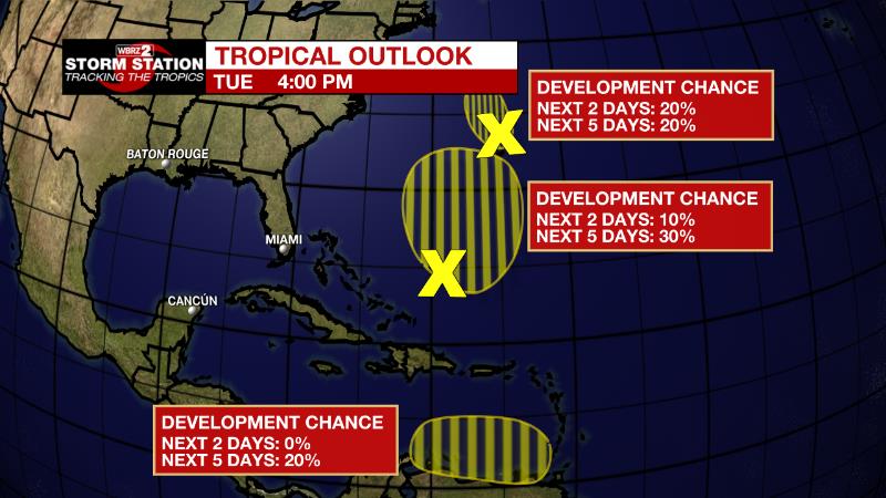
The Tropics: Shower activity associated with an area of low pressure located about 70 miles north of Bermuda remains limited. The low is moving northward over cooler waters and into an area of strong upper-level winds. Therefore, the chance for development is decreasing and down to twenty percent.
Trending News
A trough of low pressure extending from near the Turks and Caicos Islands north-northeastward for several hundred miles is producing disorganized showers and thunderstorms. Environmental conditions a thirty percent chance of gradual subtropical development of this system over the next few days while it drifts north-northeastward. By this weekend, the system is forecast to meander over the subtropical western Atlantic.
An area of low pressure could form over the eastern Caribbean Sea by early this weekend. Environmental conditions conducive for a twenty percent chance of gradual development as the low drifts westward or west-northwestward over the eastern Caribbean this weekend.
The Explanation: With a cold front to the east, winds will be out of the northwest on Wednesday and into Thursday. Dry air trailing that system will maintain low humidity and clear skies leading to diurnal temperature ranges of 25 to 30 degrees. These readings are about 5 degrees below average for the time of year. A strong upper level trough of low pressure will move across central Texas and into the Arklatex region Friday night into Saturday. A strengthening surface low pressure system and associated fronts will be draped across the Texas coastal area on Friday night before quickly translating to the northeast. With deep moisture moving in ahead of the system along with broad lift, showers will develop as the workweek ends. The low will reach I-20 by Saturday morning, pulling a cold front through the local area. Instability is expected to be too limited for severe weather, but some rumbles of thunder are possible as the front sweeps east. By Saturday afternoon, dry air to overtake the region behind that front, and moisture will be cut off, effectively ending the threat for organized precipitation.
--Josh
The Storm Station is here for you, on every platform. Your weather updates can be found on News 2, wbrz.com, and the WBRZ WX App on your Apple or Android device. Follow WBRZ Weather on Facebook and Twitter for even more weather updates while you are on the go.
More News
