

Latest Weather Blog
Thursday PM Forecast: Record highs in danger heading into this weekend
Dry air continues to invade, limiting storm chances to just about nothing in the metro area over the next week. Although we’re seeing drier air, cooler air is nowhere to be found. In fact, high temperatures will chase record values through the weekend.
Tonight & Tomorrow: Skies will be fairly quick to clear on Thursday night, with just a few passing clouds into Friday morning. We’ll wake up to a lot of sunshine on Friday, with a low temperature around sunrise near 70°. Mostly sunny skies will dominate on Friday. A spotty shower can’t be ruled out for our southern parishes (i.e. St. Mary, Assumption, etc.), but rain will be hard to come by in the metro area. It’ll be warm and muggy with a high temperature near 94°. This will flirt with the record high of 95° set in 1933 and 1953.
Up Next: The near-record heat doesn’t go away over the weekend. Middle-90s for highs will continue to be the main theme, and record values are pretty close to that. Although temperatures may begin to back off by the middle part of next week, we’re still looking at highs in the 90s. We’re also keeping the rain coverage at a 0% through mid-week.
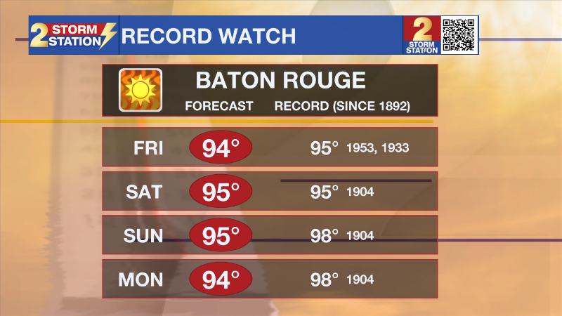
By late next week, there are some signs that cooler air will filter into the area. There’s still a lot of time for things to change, but if you’re looking for cooler temperatures, we’ll have to wait at least another week. Keep your fingers crossed for a robust cold front passage.
Trending News
Get the latest 7-day forecast and real time weather updates HERE.
Watch live news HERE.
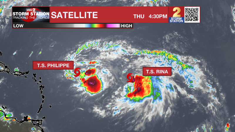
The Tropics: Tropical Storm Philippe has slowed down to a crawl and is maintaining tropical storm strength in the central Atlantic. Since Philippe is moving so slowly, there are some question marks regarding Philippes future path. This is in part due to Philippe’s proximity to a new area of development to the east. The storm will move very slowly through the weekend before taking a sharp northerly turn early next week.
Tropical Storm Rina formed east of Philippe on Thursday morning, becoming the 17th named storm of the 2023 Atlantic hurricane season. This storm will track to the northwest over the next five days and is not forecast to become a threat to land during that time.
-- Meteorologist Malcolm Byron
The Storm Station is here for you, on every platform. Your weather updates can be found on News 2, wbrz.com, and the WBRZ WX App on your Apple or Android device. Follow WBRZ Weather on Facebook and Twitter for even more weather updates while you are on the go.
More News
