

Latest Weather Blog
Thursday PM Forecast: one more pleasant day
While the Baton Rouge area began at a wildly comfortable 66 degrees, that mark was 4 degrees above the record low temperature for the date set back in 1915. Another 24 hours of pleasant weather is ahead.
Next 24 Hours: Skies will remain mostly clear overnight with calm winds. Low temperatures will take another run at the upper 60s along and north of I-12. On Friday, humidity may gradually start to return to the area, but not fast enough to make it seasonably sticky. High temperatures will get close to 90 degrees. Mostly to partly sunny skies are expected and while a modest upper level disturbance will swing over the area, the air may just a bit too dry for much more than a stray shower.
Up Next: Standard summer fare is ahead Saturday into early next week. Expect hot and humid conditions with highs in the low 90s and lows in the mid 70s. While each day will start with plenty of sunshine, isolated showers and thunderstorms will be around to dodge in the afternoons. For the 13 Parish, 3 County Forecast Area, rain coverage will be around 20 percent Saturday through Monday and then 30 percent Tuesday through Thursday. CLICK HERE for your full 7-Day Forecast.
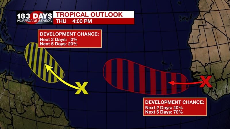
The Tropics: A tropical wave near the west coast of Africa is producing a large area of disorganized showers and thunderstorms. The wave will soon move into the eastern Atlantic Ocean where environmental conditions appear conducive for gradual development, and there is a 70 percent chance that a tropical depression will form over the weekend.
Trending News
Another tropical wave over the central tropical Atlantic continues to produce a broad area of disorganized showers and thunderstorms. Here, there is just a 20 percent chance of tropical development while the disturbance moves west-northwestward at 10 to 15 mph.
These particular systems are more than a week away from being any concern to the United States. However, it is now the time of year when we need to start to monitor the deep tropics. For the latest tropical forecasts and information, visit the WBRZ Hurricane Center as we navigate all 183 Days of Hurricane Season.
The Explanation: A fast moving upper level trough will slide across the forecast area on Friday. While this occurs, moisture will have yet to build into the area in the wake of our recent frontal passage. Fro this reason, it may be difficult for many, if any, showers to develop. Should it happen, the best chances will be closer to the lakes and coast in the afternoon. Steadily, onshore flow will return to the area this weekend. As humidity builds lake and sea breezes will lift warm inland air to allow isolated showers and thunderstorms Saturday and Sunday afternoons. Forecast models are somewhat bullish on rain coverage Monday, though they also display some upper level ridging over the area which would tend to suppress convection. Since the ridging seems more likely, the forecast will remain consistent with just isolated, afternoon showers and thunderstorms. Through the middle of next week, surface high pressure across the western Atlantic Ocean will cause steady onshore flow and maintain a typically repetitive summertime pattern. Temperatures will be near average with highs in the low 90s and lows in the mid 70s. Seasonably uncomfortable humidity will be back and help to fuel isolated to perhaps scattered afternoon showers and thunderstorms.
--Josh
The WBRZ Weather Team is here for you, on every platform. Your weather updates can be found on News 2, wbrz.com, and the WBRZ WX App on your Apple or Android device. Follow WBRZ Weather on Facebook and Twitter for even more weather updates while you are on the go.
More News
