

Latest Weather Blog
Thursday PM Forecast: fog possible tonight, rain likely late tomorrow night
Some fog is possible early Friday. A front will deliver a batch of showers and thunderstorms on Saturday.
Next 24 Hours: Skies will be mostly clear early in the night and low temperatures are expected to occur shortly after midnight in the low 60s. Increasing southeast winds will advance moisture into the local area and with that some fog will develop as temperatures begin rising into daybreak. Visibility could be reduced in some areas shortly after dawn Friday. After a peek or two of sunshine, high temperatures will hit the low 80s. Expect breezy conditions with winds out of the southeast at 10-15mph. Clouds will fill in through the afternoon with isolated showers possible.
Up Next: A weakening cold front will approach the area overnight and into Saturday. A band of showers and embedded thunderstorms will move in on Saturday morning. The first hit of rain will come in the morning hours. Briefly gusty wind and downpours are possible as the line arrives. The front will be stalling and falling apart over the area, so a period of light to moderate rain will continue through the morning hours before tapering from west to east during the afternoon. For those tailgating this weekend, expect some wet weather early. Heading into Tiger Stadium, most of the activity should be over with, but you should still take in a poncho in the event of a lingering shower. As far as thermometers go, Saturday will be muggy with morning lows near 70 degrees, afternoon highs in the mid 70s and evening temperatures retreating into the upper 60s. With the damp conditions and a breeze, you may need a windbreaker or light jacket. Sunday will be mostly cloudy and mild with high temperatures in the low 80s. CLICK HERE for your detailed 7-Day Forecast.
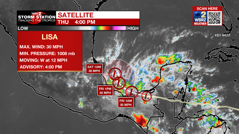
The Tropics: Lisa is dissipating over southeastern Mexico while Martin has transitioned into a powerful extratropical system in the north Atlantic.
Trending News
A weak non-tropical area of low pressure located a few hundred miles east of Bermuda continues to produce a few disorganized showers and thunderstorms. There is just a ten percent chance of development over the next few days as it moves slowly southward today and then turns westward by the weekend. The system is forecast to merge with a larger low pressure area developing to its southwest by the end of the weekend and further development is not anticipated at that time.
A large non-tropical low pressure system is expected to develop this weekend across the northeastern Caribbean sea and southwestern Atlantic. The system is expected to initially be very broad and disorganized, but environmental conditions could support a thirty percent chance of gradual subtropical or tropical development beginning early next week while it moves generally northwestward or westward over the southwestern Atlantic.
The Explanation: Into Friday, low level moisture will increase so as temperatures ease back toward the rising dew points, some fog may develop. On Friday afternoon, an upper level trough of low pressure will dig into the Lower Midwest with an associated cold front developing at the surface over Texas. With a continued build up of moisture, clouds will move over the area as the day progresses. As the trough shifts northeastward into the weekend, the cold front will be pulled across Louisiana and Mississippi on Saturday morning. A line of showers and thunderstorms is expected to enter the area around daybreak. While severe weather should be limited due to lacking ingredients and the fact that storms will move in during the coolest part of the day, one or two stronger wind gusts will be possible along the leading edge of the precipitation. As the upper level trough of low pressure continues to lift away from the front, it is expected to slow down causing the line of showers and thunderstorms to taper, but linger. So, while the bulk of the rain is expected to occur during the first half of the day, lingering showers are possible through the afternoon and even into Sunday. Going into the work week, the forecast becomes a bit uncertain, as the location and intensity of a possible subtropical cyclone over the western Atlantic remains up in the air. Given the low confidence in any one specific solution, kept the forecast to remain generally quiet through the first half of the week.
--Josh
The Storm Station is here for you, on every platform. Your weather updates can be found on News 2, wbrz.com, and the WBRZ WX App on your Apple or Android device. Follow WBRZ Weather on Facebook and Twitter for even more weather updates while you are on the go.
More News
