

Latest Weather Blog
Strong cold front stays west, humid and stormy days ahead
The near term forecast will feature a bit more humidity and stray showers and thunderstorms. By the weekend, a more active pattern should ensue.
The Next 24 Hours: With winds taking on more of an easterly component, dew point temperatures and therefore humidity have been slowly rising. Overnight will be mostly clear with lows in the low 70s. On Wednesday, mostly sunny skies will drive highs into the low 90s with just a stray afternoon shower or thunderstorm.
After That: With highs in the low 90s, lows in the mid 70s and plenty of late summer humidity, the lake and sea breeze will try to activate isolated, afternoon showers and thunderstorms to end the week. Most of the activity will occur south of I-10 and near the lakes. A weakening front will approach the region this weekend. As that front stalls, moisture will pool in the Gulf States allowing scattered, afternoon showers and thunderstorms to occur Saturday into next week. Temperatures will be close to seasonal averages of 90/71.
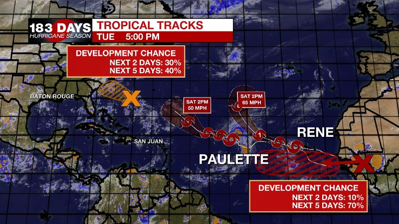
The Tropics: As of 4pm Tuesday, Tropical Storm Paulette was drifting northwest in the central Atlantic with 65mph winds. The storm may strengthen a bit more before accelerating then weakening over the next few days. Tropical Storm Rene was pulling away from the Cabo Verde Islands with winds still at 40mph. Rene will likely become a hurricane over the next few days will moving to the northwest and then northeast over the east Atlantic. Neither of these systems poses a threat to the Gulf Coast.
Trending News
An area of low pressure southwest of Bermuda has a 40 percent chance of development while it moves west over the next 5 days. The next tropical wave set to emerge off the west coast of Africa has a 70 percent chance of development.
The Explanation: As winds turn southeasterly, humidity (higher dew points) will be reinstated across the forecast area over the next several days. A slower than expected saturating of the atmosphere may mean scarce coverage in rainfall over the next few days—mainly south of I-10. By Friday, deeper moisture will aide an increase of showers and thunderstorms. Meanwhile, a deep area of upper level low pressure will slowly advance northeast through the end of the week. This low will help to amplify an upper level ridge across the eastern U.S. The ridge will cause that upper low to ride much farther north, into the Great Lakes region. As a result, the associated cold front will buckle on approach to the Southeast. However, the vigorous trough will cut into the deep ridge and decrease any subsidence in the atmosphere. That, along with a stalling and decaying front coming into the area will cause scattered showers and thunderstorms through at least Monday. Therefore, not only will the front not arrive in the area to create a cool down, but also lead humid and, at times, stormy conditions this weekend.
--Josh
The WBRZ Weather Team is here for you, on every platform. Your weather updates can be found on News 2, wbrz.com, and the WBRZ WX App on your Apple or Android device. Follow WBRZ Weather on Facebook and Twitter for even more weather updates while you are on the go.
More News
