

Latest Weather Blog
Storms exit, cooler and drier air arrive
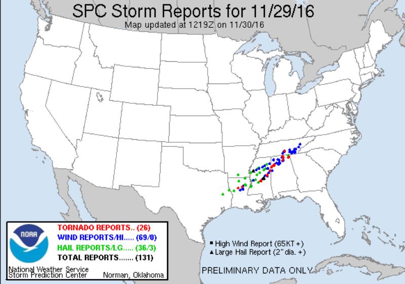
The local area dodged a big severe weather threat. The potential panned out just north of the WBRZ Weather forecast area with a swath of damage reports from Central Louisiana through Mississippi to North Alabama. The Storm Prediction Center filed 26 tornado reports yesterday afternoon and evening.
Now, much quieter weather is on tap for the remainder of the week.
THE FORECAST:
Today and Tonight: Skies will continue clearing through the day as a cold front pulls away from the area. Much cooler air is arriving and northerly winds of 5-10mph will keep highs in the mid 60s. Overnight, look for a clear sky and a chilly thermometer—bottoming out in the low 40s.
Trending News
Up Next: Thursday and Friday will continue a stretch of slightly below average temperatures with afternoon highs staying in the low 60s and morning lows in the low 40s. After abundant sunshine on Thursday, some high clouds will begin to build in on Friday. By the weekend, a Gulf of Mexico storm system is expected to spread rain across Louisiana and Mississippi making a Saturday, Sunday better suited for indoors for the first time in a while.
The Tropics: The 2016 Hurricane Season officially ends today.
THE SCIENCE:
Forecast Discussion: The slow to move upper level trough that brought two days of severe weather risk to the Central Gulf Coast is lifting northeast and flattening. The associated cold front has moved through the area and surface high pressure building in from the northwest will aid in cold air advection and a more seasonable air mass arriving through Wednesday. Temperatures will be a few degrees below average through the remainder of the week as forecast focus shifts to the next significant system. Forecast models are showing a shortwave trough pinching off into a full cut off upper low over Mexico by Saturday. This will induce cyclogenesis off of the East Texas cool season baroclinic zone. An associated warm front will lift north through the Gulf of Mexico and overrunning precipitation will begin on Saturday Morning, continuing through the day. The surface low will move northeastward, possibly intersecting a portion of Southeast Louisiana sometime Saturday Night or Sunday. The western extent of the surface low track will have a drastic impact on temperatures and the possibility of thunderstorms. For now and for consistency’s sake, we will keep forecast temps cool on Saturday Night and Sunday, but a shift west would mean part or all of the forecast area could reside in the warm sector for a period of time and thermometers would respond upward considerably. Additionally, instability in the warm sector could lead to a few thunderstorms. With regard to timing, the GFS Model has slowed, not flushing the moisture out until Monday, while the ECMWF ends precipitation Late Sunday.
--Josh
More News
