

Latest Weather Blog
Quiet finish to the workweek
Beyond showers and thunderstorms with the latest cold front, much quieter weather is expected for the rest of the week. The next chance for rain will come later in the weekend.
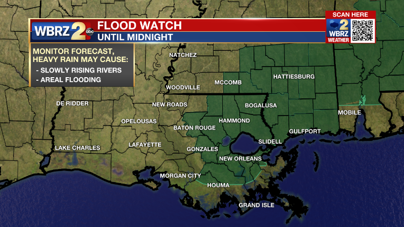
Tonight & Tomorrow: Though the threat for severe weather has passed, a few showers and thunderstorms may linger into the overnight hours. Still, some brief downpours may occur with event totals of 1-2 inches in most locations. Due to the already saturated ground from rain last week, some nuisance street and poor drainage flooding issues could crop up, especially east of Baton Rouge. A FLOOD WATCH is in effect until midnight. As winds shift westerly At 10-15mph, low temperatures will bottom in the mid 50s. On Wednesday, clouds will clear from west to east revealing sunshine for most locations during the afternoon hours. Northwest winds of 5-10mph will limit high temperatures to the upper 60s and low 70s.
Get the latest 7-day forecast and real time weather updates HERE.
Trending News
Watch live news HERE.
Up Next: Thursday and Friday will be mainly sunny and seasonable with high temperatures in the low to mid 60s and low temperatures in the low to mid 40s. One or two spots north and east of Baton Rouge could nip the upper 30s and see some patchy frost on Friday morning. The first half of the weekend will start in fine shape with sunshine and high temperatures crossing into the low 70s. Enjoy some outdoor time then because Sunday looks more gloomy. A weak cold front will settle into the area with clouds and showers. The slow mover could cause some dreary weather to hang on into early next week.
Detailed Forecast: An upper level trough of low pressure will slide over the region overnight into Wednesday shoving the cold front east and through the local area. As a result, rain will end from west to east. Winds will take on a west to northwest direction but because the air mass behind this front originated in the Pacific, the temperature drop behind the boundary will be modest. In fact, thermometers will likely stay above average on Wednesday and drop just a few degrees to be near average on Thursday and Friday. The arrival of drier air though will eliminate the threat for fog, at least through the rest of the week. A surface high pressure system will remain in control of the weather promoting mainly clear skies and dry conditions as the weekend begins. By Sunday, a new upper level trough of low pressure will move into the Great Plains. The parent trough will drive a surface cold front into the area on Sunday. Increasing low level moisture will lead to clouds and a few showers in the vicinity of the front. The upper level winds will become parallel to the boundary causing it to slow through the area and keeping some dreary conditions around into early next week.
--Josh
The Storm Station is here for you, on every platform. Your weather updates can be found on News 2, wbrz.com, and the WBRZ WX App on your Apple or Android device. Follow WBRZ Weather on Facebook and Twitter for even more weather updates while you are on the go.
More News
