

Latest Weather Blog
More active then much hotter
Contrary to what was though last week, Monday and Tuesday may feature only isolated showers and thunderstorms. Action should pick up by midweek before temperature pick up next weekend.
THE FORECAST:
Today and Tonight: Monday will be mostly sunny early with temperatures quickly climbing to a high in the low 90s by early afternoon. A few showers and thunderstorms are possible later but only isolated activity is anticipated. There is a much better chance for cooling rain east of I-55. Overnight lows will barely drop into the mid 70s.
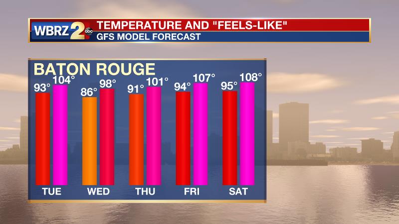
Up Next: Tuesday is a tricky forecast, as it will be a transitional weather day with slightly more shower and thunderstorm activity than Monday. As the action will still be limited to the afternoon, high heat will remain a part of the forecast. By Wednesday and Thursday, the atmosphere should “unlid” allowing for scattered to widespread showers and thunderstorms and therefore high temperatures closer to or perhaps a few degrees below average. Rain chances will quickly diminish by the weekend allowing thermometers to bubble back up in a big way. Some of the hottest air of the season is expected Friday through Sunday. Feels-like temperatures will be between 105 and 110 degrees.
Trending News
The Tropics: Beryl has become post-tropical and is now harmlessly in the North Atlantic. In the remainder of the basin, no development is expected over the next 5 days.
THE EXPLANATION:
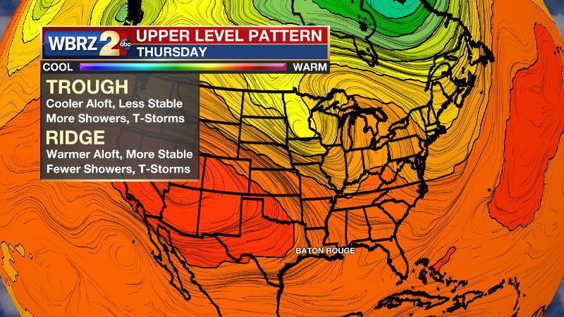
A stubborn 500mb ridge is not breaking away to the west as quickly as anticipated. Therefore, some subsidence remains in the atmosphere and will curtail scattered or widespread convection west of I-55 through Monday. This means temperatures will stay hotter longer and heat indices will spend several hours above 100 degrees. Additionally, the added duration of heat will allow for instability to build and any showers and thunderstorms that can break through will have plenty of energy to quickly turn strong or possible severe. Downpours, frequent lightning and gusty wind will be possible with any boomers. Slow moving storms will be capable of dropping a quick inch or two of rain and therefore could create some nuisance flooding. Tuesday, the position of the ridge is still in question. Should it jut west, expect a more active day, if it remains stubborn than the forecast will be similar to Monday. Eventually, a northern stream trough will penetrate the Eastern U.S., which should lead to at least a few active days of shower and thunderstorm activity—mainly Wednesday and Thursday. Along with broad lift and more instability caused by the trough, precipitable water will increase to the 2.25” range, which is near a record value for the time of year and will continue the threat for locally high rain totals. By next weekend, the upper level ridge will return with vengeance. Not only will the ridge suppress convection and disallow any afternoon cooling, but also lead to increased compressional warming and prolonged, dangerous heat. Highs will easily reach the mid and potentially upper 90s. Leftover surface moisture from midweek rain will have dew points running high and heat indices could be between 105-110 degrees. The National Weather Service says standby for the possibility of heat warnings.
--Dr. Josh
The WBRZ Weather Team is here for you, on every platform. Your weather updates can be found on News 2, wbrz.com, and the WBRZ WX App. on Apple and Android devices. Follow WBRZ Weather on Facebook and Twitter for even more weather updates while you are on the go.
More News
