

Latest Weather Blog
Monday PM Forecast: near record warmth, late week cold front
A record high temperature fell at Baton Rouge Metropolitan Airport on Monday. 87 degrees was good enough to beat a 2005 mark of 85 degrees.
Next 24 Hours: Skies will be mostly clear overnight with some patchy fog possible by morning. Low temperatures will be in the upper 60s. On Tuesday, mostly sunny skies will help to drive high temperatures into the upper 80s and potentially near records once again. The standing mark at Metro Airport (data since 1930) is 87 degrees.
Be sure you keep your eyes on the skies early tomorrow morning, you will not want to miss this.
— WBRZ News (@WBRZ) November 7, 2022
Timing and visibility is all tracked out here: https://t.co/I4qt8xjCiW pic.twitter.com/ddWCXDImgl
Up Next: The rest of the workweek will be quiet, mostly clear and temperatures will be a little closer to seasonable averages. On Friday, a strong cold front will ship into the area. The front itself will be starved of moisture making any rainfall unlikely. However, north winds behind it will bring on a substantial temperature drop heading into the weekend. Expect high temperatures in the 60s and low temperatures in the 40s—if not 30s in some neighborhoods north of Baton Rouge. CLICK HERE for your detailed 7-Day Forecast.
Trending News
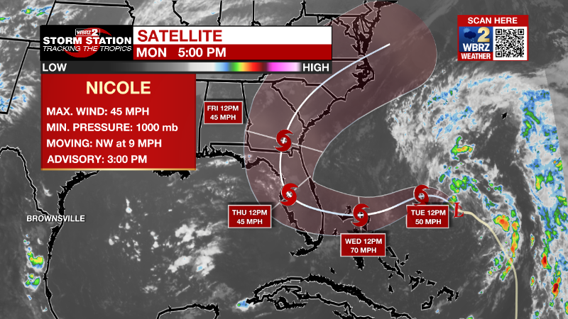
The Tropics: Subtropical Storm Nicole is expected to strengthen on approach to the Bahamas and Florida later this week. As of 4pm Monday, maximum sustained winds were 45 mph and Nicole was moving northwest at 9mph. A slower northwestward motion is expected tonight followed by a turn toward the west or west-southwest Tuesday night through early Thursday. Strengthening is expected and Nicole is forecast to be at or near hurricane intensity by landfall on Wednesday and Thursday. Hurricane conditions, including surge up to 5 feet and rain up to 5 inches are expected across parts of the Bahamas and Florida.
An area of low pressure located about 700 miles east of Bermuda is producing winds near gale force, and a small area of showers and thunderstorms far removed to the east of the low's surface center. The system is accelerating northeastward toward cooler waters, while remaining in a region of strong upper-level winds. Consequently, the chance for significant development is quickly diminishing.
The Explanation: After another unseasonably warm day, drier air will begin to spill into the region from the northwest on Tuesday night. That will limit fog development and allow temperatures to drop back several degrees. Still, highs and lows will be above average for the time of year. The second half of the work week will be a transition period as that drier air mass is reinforced by Nicole to our east. As Nicole moves across the Florida peninsula during the second half of the week, a strong upper level trough of low pressure and will be moving toward the Great Lakes region with an associated cold front draped southwestward across the United States. Thanks to that approaching front, Nicole will not have any direct impacts on the local area. On the other side of the front, lows both Saturday night and Sunday night are expected to dip into the 30s along and north of the I-10/12 corridor. Daytime highs are also going to drop well below normal, with current forecast highs for Sunday and Monday only reaching the upper 50s to mid 60s.
--Josh
The Storm Station is here for you, on every platform. Your weather updates can be found on News 2, wbrz.com, and the WBRZ WX App on your Apple or Android device. Follow WBRZ Weather on Facebook and Twitter for even more weather updates while you are on the go.
More News
