

Latest Weather Blog
Monday PM Forecast: heat dome to dominate, set more records
With the big ridge of high pressure, or heat dome, staking position over the central United States, record-breaking heat will continue. Some of the area’s hottest temperatures of all-time are anticipated this week.
A ***RED FLAG WARNING*** will be in effect on Tuesday. Dry conditions, hot temperatures, low humidity and persistent breezes will lead to critical fire weather and burning should be avoided at all costs.
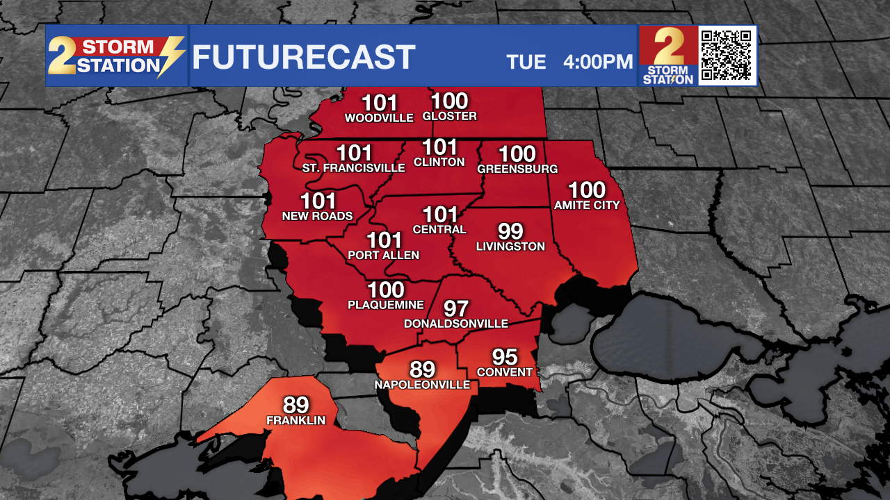
A ***HEAT ADVISORY*** will be in effect on Tuesday. Hot temperatures in the upper 90s and low 100s will pair with enough humidity to create feels-like temperatures over 107 degrees. Remain hydrated and don’t overexert outdoors.
Tonight & Tomorrow: A weak tropical system, designated as Potential Tropical Cyclone Nine will continue racing west across the Gulf of Mexico overnight. Well south of the local area, this system will only provide a few extra clouds and possibly a rogue shower. Low temperatures will stop near 80 degrees. On Tuesday, the tropical system will move farther away to the southwest taking any low rain chances with it. Skies will be partly sunny. High temperatures will top out near 100 degrees with enough humidity for feels-like temperatures between 107 and 113 degrees.
Trending News
Up Next: To end the workweek, the heat dome will dominate. Mornings will start in the low 80s. Afternoons will be mostly sunny with high temperatures surging into the 100 – 105 degree range. Several afternoons are expected to flirt with all-time record high temperatures for Metro Airport. That mark stands at 105 degrees, set on Saturday and Sunday afternoons as well as on August 30, 2000. Humidity may not be quite as high as previous weeks, but the air temperatures will compensate for this to cause feels-like temperatures over 113 degrees. If you are wondering when the heat may let up a bit, there are just no signs of it over the next 7 to 10 days.
Get the latest 7-day forecast and real time weather updates HERE.
Watch live news HERE.
The Tropics: Potential Tropical Cyclone Nine was designated on Monday. The system is expected to reach tropical storm status before reaching southeast Texas. Coastal flooding, winds over 40mph and rainfall of 3-5 inches is expected across portions of south Texas into Tuesday. Mountainous areas of northern Mexico could have mudslides. The storm will dissipate over land by the middle of the week.
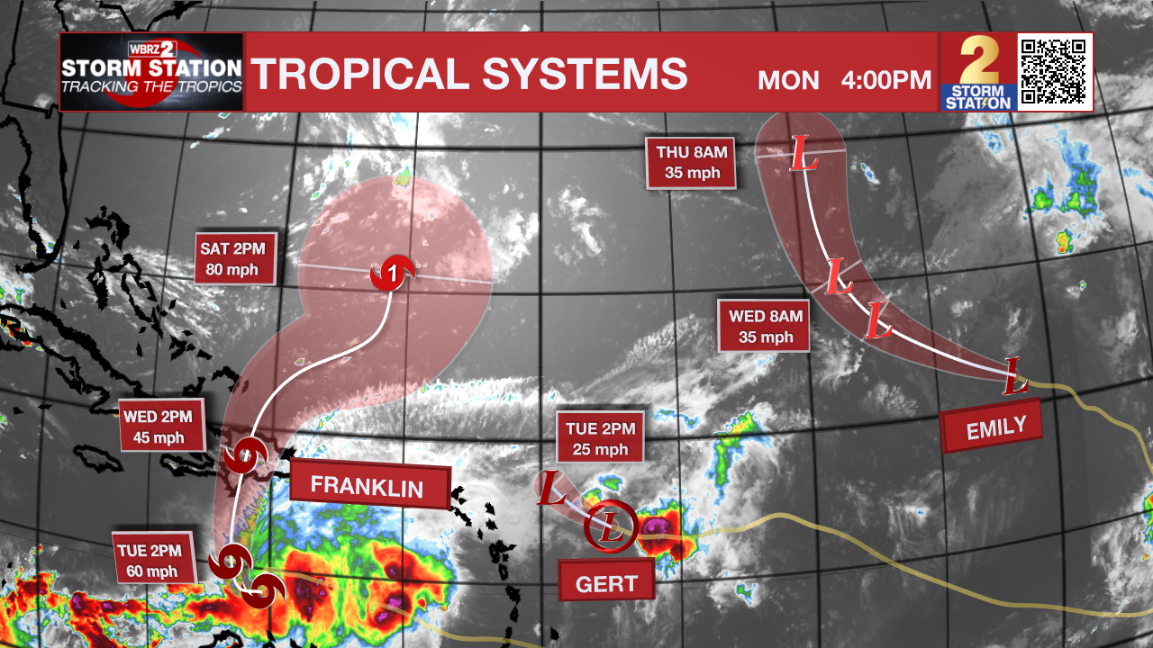
Tropical Storm Franklin is churning west across the eastern Caribbean Sea at 4mph with maximum sustained winds of 50mph. The storm is expected to make a sharp turn north on Tuesday with some strengthening possible. Franklin will bring heavy rain across Puerto Rico, Hispaniola, Haiti and the Dominican Republic causing flash flooding and mudslides. After that, it will turn northeast across the southwest Atlantic Ocean and possibly reach hurricane strength.
Tropical Depressions Emily and Gert are weakening across the central and eastern Atlantic Ocean respectively. Both will be post-tropical and dissipate by Tuesday. Neither system poses a threat to any land.
--Josh
The Storm Station is here for you, on every platform. Your weather updates can be found on News 2, wbrz.com, and the WBRZ WX App on your Apple or Android device. Follow WBRZ Weather on Facebook and Twitter for even more weather updates while you are on the go.
More News
