

Latest Weather Blog
Low to no impact weather for holiday travel
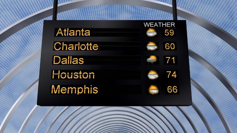
For Wednesday, the travel forecast is in good shape for the eastern two-thirds of the nation. While a light rain shower is possible from Iowa southward to Texas, no major delays should occur due to weather.
THE FORECAST:
Today and Tonight: Locally, we expect increasing clouds with a high approaching 70. A spotty sprinkle or light shower isn’t out of the question—but it wouldn’t measure up to anything. Winds will blow out of the east-southeast around 10 mph. Overnight will be partly cloudy with a low near 60. Flip that heat, A/C switch again.
Looking Ahead: Thanksgiving and Black Friday will present more clouds than sun. Highs will be mild, in the mid 70s, with overnight lows around 60. A light shower is possible, but not likely, and anything that does fall will be insignificant. Clouds and mild temperatures will stick around into the weekend and rain chance increase on Sunday.
Trending News
THE SCIENCE:
Forecast Discussion: Winds have taken an east-southeasterly turn as a surface high pressure has become well established in the Northeastern United States. Meanwhile, the next big trough is moving over the Pacific West and will complicate forecasts through the weekend. For the busy travel day ahead, commuters by air and ground will meet little weather resistance east of the Mississippi River. A developing cold front could create some light rain from Iowa to Texas but nothing significant is expected. By Thanksgiving, the upper trough is depicted as a cutoff on most models. This will strand a cold front from Michigan to Texas with a southwesterly stream of moisture from the Tropical Pacific. The local area should be well away from any serious forcing and thus spared from little more than a passing shower through Saturday. Clouds will likely be more prevalent than sun though as a mid-level ridge creates that temperature inversion which will make any moisture injection stubborn to mix out. By Sunday, the trough is expected to become absorbed into the westerlies and finally guide the surface front eastward. However, much of the moisture will have been tapped and moving into a relatively stable area, little more than scattered showers are expected at this time. Model agreement is poor, but the idea of a Monday frontal passage seems logical with cooler temperatures coming in behind. There remains considerable uncertainty for the late weekend and beyond time frame, so stay with us!
--Josh
Stay connected with me… share your thoughts!
Twitter: @Josh_Eachus
Google+: Josh Eachus
Facebook: Meteorologist Josh Eachus
More News
