

Latest Weather Blog
High risk for flash flooding through Saturday morning
After some areas of the Bayou State have already received over a foot of rain since Wednesday, an additional 4-7” of rain is expected to fall by the end of the weekend.

The National Atomospheric and Oceanic Administration's Weather Prediction Center has issued a HIGH risk for FLASH FLOODING through Saturday morning. This is different than the river flooding we experienced a few months ago where flooding was gradual. FLASH FLOODING occurs when a significant amount of rain falls in a considerably small amount of time. It can be much more rapid.

Monitor the weather closely in the event that any flooding issues develop. The fastest updates in the city of Baton Rouge are found on our social media accounts @WBRZweather.
~~~
What to Expect: A threat for 4-7” of rain with locally higher amounts as thunderstorm downpours will create localized street flooding. For this reason, a FLASH FLOOD WATCH has been issued into Saturday Morning for the entire forecast area. Depending on where the heaviest rain occurs, rivers flooding may become a concern as well. At this time, only minor flooding is expected on the Comite River at Joor Road, Amite River at Denham Springs, Amite River at Bayou Manchac, Tickfaw River at Liverpool, and the Tangipahoa at Robert.
Trending News

Timing: Rounds of heavy showers and thunderstorms are expected not just during the day but at night as well. Any storms now through Friday Night bring the most widespread flooding threat. However, scattered showers and thunderstorms over the weekend will contribute to the forecast rain totals as well.
What should I do? The forecast is issued on the basis that conditions are favorable for showers and thunderstorms to create flooding issues. Know that things may change! There a couple of things you can do to be ready.
--Stay in touch with the WBRZ Weather Team for updates and alerts.
--If you live in a flood prone area, prepare now, just in case.
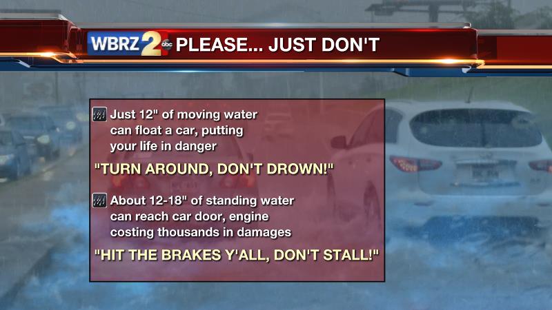
--If you come across rushing water, turn around don’t drown! Several inches of moving water can float a car.
--If you come across a flooded street, hit the brakes y’all, don’t stall! Once the water reaches car doors or engines, damages run into the thousands of dollars. Even if a street you travel every day has standing water, do not attempt to drive across it. Every flooding event, we receive video of cars floating away or people pushing their car out of the floodwater.
After the Threat: Into the weekend, scattered showers and thunderstorms are expected to continue, but not in the amounts we're experiencing now as daily rain coverage and totals will be trending down. High temperatures will be near 90 with lows in the mid 70s. Next week a more standard summer pattern will gradually return with more heat, steam and flare up showers and storms during the afternoons.
--RGIII
For updates, stay connected with Meteorologist Josh Robert Gauthreaux
Facebook: Meteorologist Robert Gauthreaux III
~
En Español: Meteorólogo Roberto Gauthreaux III
In American Sign Language: Meteorologist Robert Gauthreaux III - ASL
More News
