

Latest Weather Blog
Friday PM Forecast: wet pattern continues through weekend
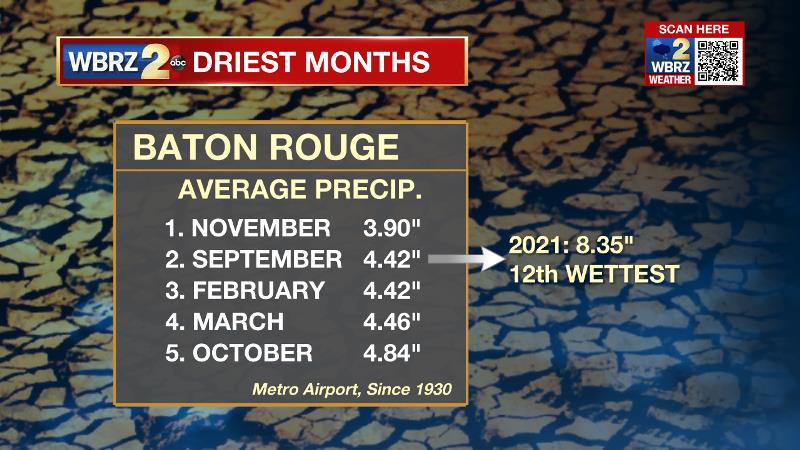
Still, the second wettest year on record, September continued the rainy weather with 8.35 inches coming down and that is almost double the average. The showers and thunderstorms remain in the forecast through Monday before a cold front switches the pattern.
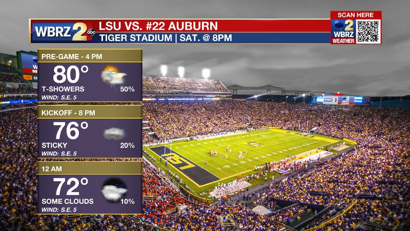
Next 24 Hours: With the loss of daytime warming, rain coverage will fade overnight. Low temperatures will be muggy in the low 70s. There is no reason to believe the pattern will change on Saturday. Thermometers will take another run into the 80s with some breaks of sun. Those heading out to the LSU campus for game day festivities should pack an umbrella or a poncho as a precaution. While the day is not expected to be a washout, an afternoon shower or thunderstorm is possible. Deeper into the evening, rain chances will subside.
Trending News
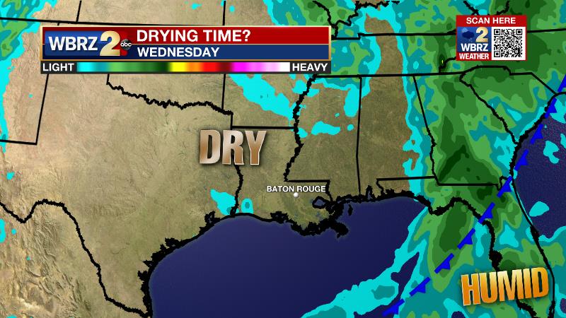
Up Next: Sunday and Monday will bring scattered showers and thunderstorms ahead of a cold front. That boundary should pass through the area by Tuesday morning to lower rain chances, temperatures and humidity for at least a few days next week. This part of the forecast has a few caveats. While drier weather and lower humidity is expected, it is unclear how quickly and how much skies clear. The amount of cloud cover will have a bigger impact on afternoon temperatures with readings staying lower if the clouds linger. CLICK HERE for your full 7-Day Forecast.
The Tropics: Category Four Hurricane Sam is an impressive storm, still churning east of Bermuda. Few systems have held this much strength, for this length of time, at this point in the season. As Sam begins to turn northeast into the northern Atlantic, gradual weakening is expected into earl next week. Tropical Storm Victor will slowly weaken through the weekend while moving northwest over the eastern Atlantic. For the latest tropical forecasts, advisories and information, visit the WBRZ Hurricane Center as we navigate all 183 Days of Hurricane Season.
While never causing major impacts to land, Hurricane #Sam has been an impressive storm. Dating back to 1966 (satellite era), it is only one of three to form on/after Sept. 23 and generate this much energy. Info via @philklotzbach pic.twitter.com/7GZ4V5PM9Z
— Josh Eachus (@DrJoshWX) October 1, 2021
The Explanation: The atmosphere will remain abnormally moist for the time of year. So, as weak disturbances roll through the upper levels, scattered showers and thunderstorms will be possible through Sunday. Daytime warming will also be needed to activate convection so afternoons will be the busiest periods. As instability lessens into the evenings, the next few nights will by dry. A more substantial upper level trough of low pressure will dive out of the Great Lakes region into the Southeast U.S. early next week. An associated cold front will also move into the region for one more day of scattered showers and thunderstorms. This upper level low pressure complicates the forecast for next week. On one hand, there is confidence that the front will fully cross the area and a drier trend is expected as a result. On the other hand, it is unclear how strong the trough will be and how much it will move. If the trough moves along to the east, Wednesday through Friday will be dry and seasonable with some clearing in skies. If the trough stagnates, clouds could linger for a few days resulting in even cooler temperatures, especially during the days.
--Josh
The WBRZ Weather Team is here for you, on every platform. Your weather updates can be found on News 2, wbrz.com, and the WBRZ WX App on your Apple or Android device. Follow WBRZ Weather on Facebook and Twitter for even more weather updates while you are on the go.
More News
