

Latest Weather Blog
Friday PM Forecast: high heat before switch to rainy pattern
As of 3pm on Friday, the Baton Rouge Area heat index maximized at 111 degrees. With similar conditions expected on Saturday, the National Weather Service has issued a HEAT ADVISORY from 10am – 8pm for local parishes and counties along and north of I-10. This means hot temperatures and high humidity may cause heat illnesses to occur.
The current heat index is 111°. With similar conditions expected tomorrow, a HEAT ADVISORY has been issued for areas along and north of I-10. https://t.co/7ZgtWDyn0y
— Josh Eachus (@DrJoshWX) July 8, 2022
You should drink plenty of fluids, stay in an air-conditioned room, stay out of the sun, and check up on relatives and neighbors. Young children and pets should never be left unattended in vehicles under any circumstances. Take extra precautions if you work or spend time outside. When possible reschedule strenuous activities to early morning or evening. Know the signs and symptoms of heat exhaustion and heat stroke. Wear lightweight and loose fitting clothing when possible. To reduce risk during outdoor work, the Occupational Safety and Health Administration recommends scheduling frequent rest breaks in shaded or air conditioned environments. Anyone overcome by heat should be moved to a cool and shaded location. Heat stroke is an emergency!
Next 24 Hours: Tonight will be mostly clear and muggy with low temperatures in the mid to upper 70s. Saturday will be hot and steamy with high temperatures running into the mid 90s. Oppressive dew points in the mid to upper 70s will cause feels-like temperatures between 108 – 113 degrees. Pop up showers and thunderstorms are possible, but should still be limited in duration and coverage when compared to earlier in the week.
Trending News
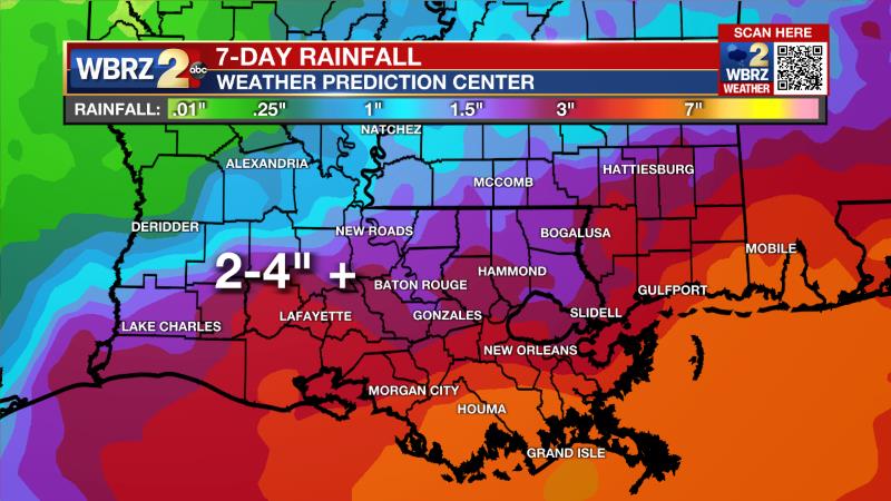
Up Next: A weakening cold front will move into the region Saturday night and could send a cluster of thunderstorms toward the I-10/12 corridor before dawn Sunday. That stalling front will then be a player in the local weather for the second half of the weekend well into next week. Daily showers and thunderstorms will occur in most locations with about 2-4 inches of rainfall through next Thursday. Of course, some point locations could receive much higher amounts due to storm downpours, leading to poor drainage flooding. The active weather will keep highs a few clicks below average, in the upper 80s. However, the humidity is not going anywhere as a full frontal passage and changing air mass is not in the cards. CLICK HERE for your detailed 7-Day Forecast.
The Tropics: For the Gulf of Mexico, Caribbean Sea and Atlantic Ocean, there are no active tropical systems. No development is expected over the next five days.
The Explanation: While upper level moisture has remained well above average, a brief duration beneath an upper level ridge of high pressure has kept convection to average levels over the last few days. In the absence of widespread showers and thunderstorms, temperatures have soared, pushing the hat index over 108 degrees. With similar conditions anticipated on Saturday, a HEAT ADVISORY has been issued. By Saturday night and Sunday, an upper level trough of low pressure will begin to break down the ridge pushing a weak front toward the Gulf Coast. This feature will provide a lifting mechanism to generate scattered to widespread showers and thunderstorms on the second half of the weekend and well into next week. Any thunderstorms will be capable of downpours, frequent lightning and gusty wind. With the very moist summer air mass, any spots that receive heavy thunderstorms, especially on back-to-back days, could see some street and poor drainage flooding. In general, 2-4 inches of rain is expected across the area with small, point locations picking up double those amounts.
--Josh
The Storm Station is here for you, on every platform. Your weather updates can be found on News 2, wbrz.com, and the WBRZ WX App on your Apple or Android device. Follow WBRZ Weather on Facebook and Twitter for even more weather updates while you are on the go.
More News
