

Latest Weather Blog
Friday dry, Saturday turns wet
An afternoon more becoming of early summer is ahead for the final weekday in April. Meanwhile, outdoor weekend events will have to be mindful of widespread shower and thunderstorm activity.
THE FORECAST:
Today and Tonight: To wrap up the week, we’ll catch a break from the showers and thunderstorms. With a good deal of sunshine, high temperatures will climb into the upper 80s. It will be quite humid as well. Overnight, quiet conditions are expected to continue with lows around 70 degrees.
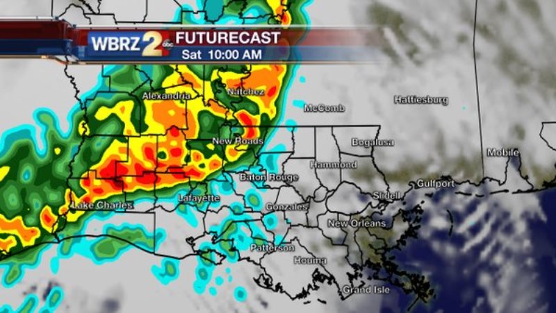
Up Next: Some adjustments have been made to the weekend forecast. While the morning hours continue to look dry, a line of showers and thunderstorms is currently shown by forecast models to reach the area by afternoon. Timing will be crucial to outdoor events on Saturday. Check in with @WBRZweather on Twitter or the free WBRZ WX app. for the location of approaching storms. Conditions otherwise will be warm and muggy with a high in the mid 80s. Sunday is still expected to be unsettled with periods of rain and thunderstorms. After a muggy start around 70 degrees, highs will be limited to the low 80s. Scattered showers and storms will continue through Tuesday.
Trending News
THE SCIENCE:
Forecast Discussion: A subtle ridge axis in the upper levels should be enough to keep the region rain-free through Friday. Don’t mistake the lack of rain for “dry” conditions as it will be humid out there. With continued southerly winds, moisture transport from the Gulf of Mexico will maintain dew points in the upper 60s providing a summer level of humidity. Into Saturday, the next upper trough extending across the Mid South will kick up a surface low pressure system and cold front in Texas. An initial squall line associated with that front may blow ahead of the front associated with an upper trough axis—possibly bringing showers and thunderstorms into the region as early as Midday Saturday. By Sunday, the cold front will drag eastward into the local area providing a lifting mechanism for an unstable air mass. The result will be periods of rain and thunderstorms dictated by energy in the upper levels which is shown by forecast models to be ever-present on Sunday. Therefore, extended dry spells on Sunday are not a safe bet at this point. The front will stall out along the coast on Monday leaving a focus in place with showers and thunderstorms to spark. On Tuesday, forecast models show a wave of low pressure developing along the coast, bringing one final unsettled day before a high pressure settling into the Midwest flushes the region out by Wednesday. Clear skies and cooler than average temperatures are in store for the end of next week.
For updates, stay connected with Meteorologist Josh Eachus:
More News
