

Latest Weather Blog
Fog to sun again and again
An area of high pressure in the northeastern Gulf of Mexico will be creating a repetitive weather pattern through Wednesday.
THE FORECAST:
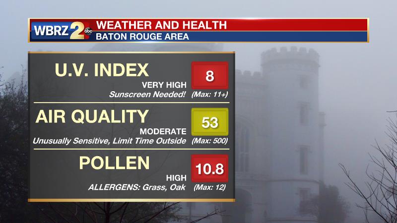
Today and Tonight: Like Monday, Tuesday will have some early fog and low clouds followed by plenty of afternoon sunshine. High temperatures will once again head for the low 80s with southwest winds of 5-10mph. Keep in mind that the sunny and dry conditions will mean a high U.V. Index and high pollen count. Sunscreen and allergy medications (for those that need it) should be used. Overnight will be clear early with fog late and a low temperature in the low 60s.
Up Next: Wednesday will be another repeat. A little less fog is anticipated Thursday and especially Friday although mostly sunny skies will prevail with highs in the low 80s. A storm system will bring the threat of showers and thunderstorms, some possibly strong, for the first half of the weekend.
THE SCIENCE: Clear skies and light winds will lead to fog development the next couple of mornings as temperatures back down into the low 60s—saturating with dew points in a similar range. An area of high pressure in the northeastern Gulf of Mexico will maintain the quiet pattern through Wednesday and even Thursday as it shifts off of the eastern seaboard. A very weak front may cause temperature to ratchet down a notch on Thursday and Friday. By the weekend, a well-defined shortwave trough showing up on the forecast models should cause a cold front to move into the region. Plenty of vorticity and clashing air masses will result in showers and thunderstorms. While possible modes of severe weather remain in question, as wind fields and parameters become apparent on forecast models these details will become more clear. Even at this early stage in the forecast, the SPC does have an area north of I-12 highlighted at risk for severe storms.
--Josh
Trending News
More News
