

Latest Weather Blog
Feasting on sun through the weekend
A four day stretch of pleasant weather is kicked off on this Thanksgiving.
THE FORECAST:
Today and Tonight: Your Thanksgiving will be sunny and seasonably mild with a high temperatures in the mid 70s—just about 5 degrees above average. Winds will be light and northerly. For LSU Football in College Station this evening, game time temperatures will be in the mid 60s and falling beneath mostly clear skies. Locally, skies will also be mostly clear with lows near 50 degrees.
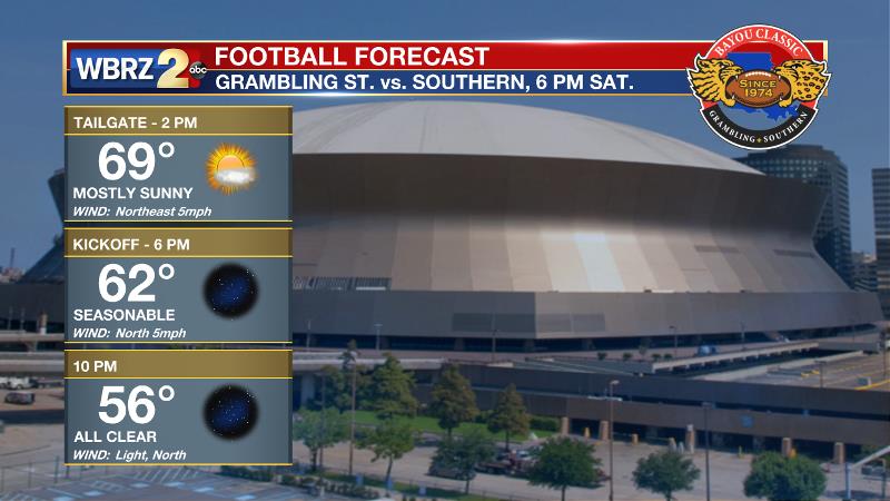
Up Next: Seasonable and tranquil weather will carry into Black Friday. Shoppers will want an extra layer in the morning before highs peak in the mid 70s with mostly sunny afternoon skies. Saturday and Sunday will remain mostly clear with just a few high clouds at times, highs in the low 70s and lows in the low to mid 40s. The Bayou Classic in neighboring New Orleans will feature similarly pleasant weather. Into next week, a storm system will offer rain and potentially strong storms by Tuesday.
Trending News
The Tropics: We’re thankful for the hurricane hunters on this Thanksgiving who have discovered an even stronger Hurricane Otto just prior to a landfall in Costa Rica. The storm has maximum sustained winds of 105mph and a minimum central pressure of 976mb. 6-12” of rain and 4-8’ storm surge is expected in parts of Costa Rica and Nicaragua. This system will move into the Pacific Ocean next week but have no effect on the United States.
THE SCIENCE:
A weak ridge of high pressure will meander over the forecast area through the weekend. Minor disturbances moving through the mean flow could occasionally provide some cirrus clouds but mainly clear skies are anticipated through Sunday. At the surface, high pressure will settle into Arkansas Friday and Saturday allowing northerly wind flow to bring a general downward trend in temperatures. Highs and lows will be much closer to normal as a result. Into early next week, the high pressure will shift eastward bringing southeasterly winds and moisture return. A deepening longwave trough in the Western U.S. will induce cyclogenesis and a fairly potent late fall storm system is expected to develop. This will bring perhaps the best shot at rain in some time with the GFS, ECMWF models and the Weather Prediction Center suggesting 1-2” will be possible. Locally, elevated moisture content, frontal lift and speed shear may contribute to a severe weather possibility, however the track of the surface low much farther north where instability and directional shear are greater means the threat should be worse elsewhere. This is most certainly the time of year though that severe weather hits a second peak, so stay with us. Behind the front, look for another shot of cold air with 60s/30s once again in play.
--Josh
More News
