

Latest Weather Blog
Back to the 4 P's, coldest Louisiana Marathon yet
Cold and quiet weather is ahead. With a busy weekend of running in the Capital City, participants and guests of the Louisiana Marathon should plan to bundle up. In addition, Louisiana and Mississippi locals might once again make preparations for the four P’s. Have a warm place for people, pets and sensitive plants; also, be sure that any exposed outdoor pipes are well insulated.
THE FORECAST:
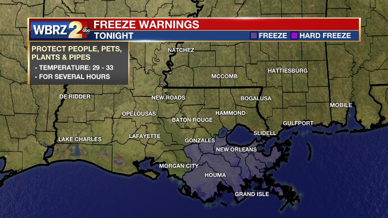
Today and Tonight: Any lingering cloud cover will break up by Friday afternoon. Temperatures will be generally steady in the mid 40s, perhaps climbing briefly into the upper 40s in response to any sun. However, most of the warming will be counter balanced by cold northerly winds of 10-15mph. For this reason, exposed skin will feel a temperature much lower with wind chills in the upper 20s and low 30s. A clear and freezing night is expected with low temperatures getting down into the upper 20s. A FREEZE WARNING has been issued for locations south of I-10. Why not north even though even colder temperatures are expected there? A FREEZE WARNING is only issued for the first TWO light freezes of the season which effectively end the growing season. A HARD FREEZE WARNING is issued when temperatures are expected to go below 25 degrees which may create pipe problems.
Up Next: This weekend, morning temperatures will be below freezing with highs only climbing into the mid to upper 40s during the afternoon hours. Skies will stay clear throughout though. On Sunday morning, lows could fall as low as the mid 20s constituting a hard freeze. A reinforcing shot of cold air on Tuesday will keep southeast Louisiana and southwest Mississippi temperatures below average through much of next week.
Trending News
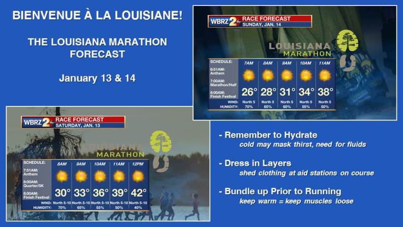
Louisiana Marathon: Runners and spectators of the Louisiana Marathon will want to dress for the coldest race yet in the event’s seventh edition. Start time temperatures will be below freezing and only recover to the mid to upper 30s by the time finishers cross the line. Winds will make it feel a bit colder, especially on Saturday. Fortunately, sun will be out in full both days.
The Explanation: Behind the front, cold air advection will continue through Friday and daytime highs will be at least 20 degrees cooler and struggle to reach 50 degrees. Any stubborn cloudiness will keep thermometers lower, longer. Clearing skies and the cold pool from an upper level trough will result in lows dropping into the upper 20s and lower 30s across the entire forecast area Friday night. This will just be the beginning of another extended period in the freezer with regard to overnight lows. Highs will only climb into the middle to upper 40s both Saturday and Sunday, but lows Saturday night should fall into the lower to middle 20s with a hard freeze likely along and north of I-10/12. Forecast models suggest another quick reinforcing shot of cold air on Tuesday with little to no rain in sight.
--Dr. Josh
The WBRZ Weather Team is here for you, on every platform. Your weather updates can be found on News 2, wbrz.com, and the WBRZ WX App. on Apple and Android devices. Follow WBRZ Weather on Facebook and Twitter for even more weather updates while you are on the go.
More News
