

Latest Weather Blog
Saturday PM Forecast: Afternoon storm coverage peaks Monday before we turn much drier
Afternoon storm coverage will slowly increase before peaking around 50% Monday. After this point, storm coverage will go down and temperatures will heat up!

Tonight & Tomorrow: The typical summer cycle is not going anywhere! Any storms that formed this evening should fizzle in the overnight hours. Lows will reach near 76° under mostly clear skies. Sunday will start off quiet and sunny, leading to a rapid warmup of temperatures. Highs will once again reach into the mid-90s, with peak heat index values between 100-107°. In the afternoon, isolated showers and thunderstorms will form, but not everyone will get wet. Actually, more locations will stay dry given rain coverage will max out around 30-40%. Just always be aware of lightning, as any summer storm can produce some bolts.
Trending News

Use the slider to advance through the next 24 hours of Futurecast
Up Next: Rain coverage will peak on Monday as the atmosphere moisten up a bit more. A washout is not expected and a decent chunk of the area will still miss out on measurable rainfall. Tuesday and Wednesday will be the transition days to a less active and hotter weather pattern. By Thursday, we will be almost bone dry, with highs in the mid-90s. The peak of the heat arrives Friday, lasting all the way through early that next week. Highs in the upper 90s will be likely. Peak heat index values of 105-110° are expected, with higher values possible. Heat alerts look to likely make a return at this time.
Get the latest 7-day forecast and real-time weather updates HERE.
Watch live news HERE.
The Tropics:
Central Tropical Atlantic:
A tropical wave is located a few hundred miles southwest of the Cabo Verde Islands. Some gradual development is possible during the early to middle part of next week while the system moves westward across the central tropical Atlantic. Upper-level winds are expected to become much less conducive for development later in the week when the system approaches the Lesser Antilles.
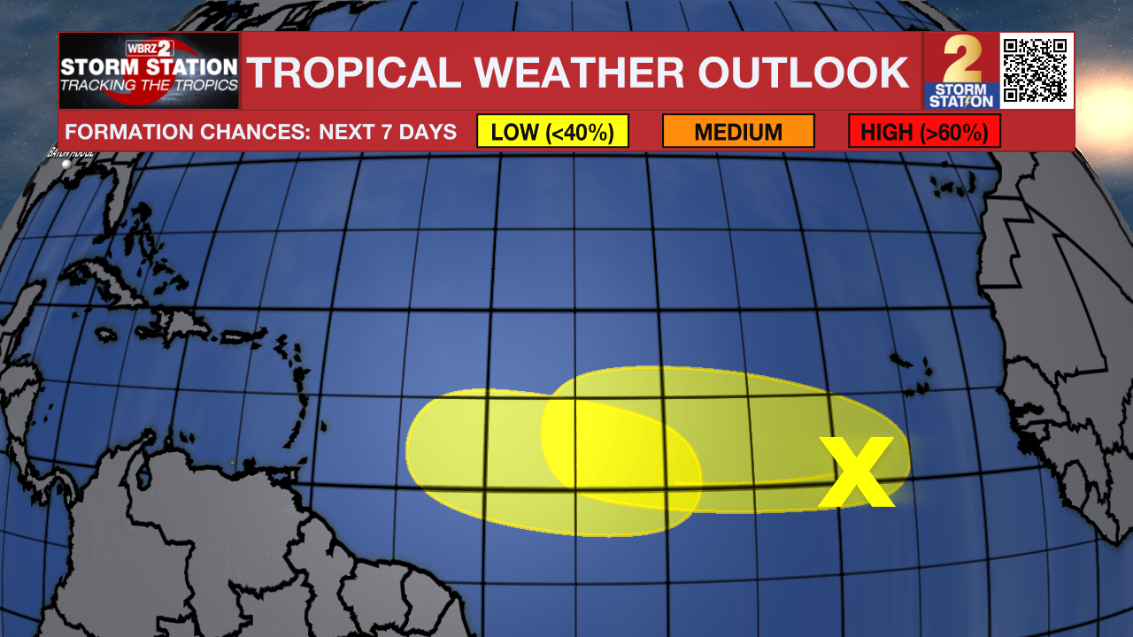
Another tropical wave is expected to move off the west coast of Africa on Tuesday. Some development of this system will be possible during the middle to latter part of next week while it moves westward across the eastern and central tropical Atlantic.
– Balin
The Storm Station is here for you, on every platform. Your weather updates can be found on News 2, wbrz.com, and the WBRZ WX App on your Apple or Android device. Follow WBRZ Weather on Facebook and X for even more weather updates while you are on the go.
More News

