

Latest Weather Blog
Monday PM Forecast: Lingering storm threat ahead of a break in the soggy pattern
Just like Monday, Tuesday could start wet for some as well. Though storms remain in the forecast a bit longer, the Capital Area is about to break out of the wet pattern. This will pave the way for summer heat to return.
Tonight & Tomorrow: Expect clouds and a few showers to linger into the evening. An overnight disturbance will likely trigger additional storms, especially south of I-12 and near the coast. The storminess may persist into the Tuesday morning drive, so consider allowing extra drive time in case of slick roads. The rest of the day could turn out mainly dry if storms remain offshore, choking off the moisture needed for inland redevelopment. However, there are some indications that these may clear up in time to allow for scattered afternoon storms to redevelop. Under a mostly cloudy sky, highs will have a tough time hitting 90°, likely stopping just short in the upper 80s.

Use the slider to advance through the next 24 hours of Futurecast
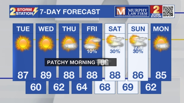
Up Next: Storm activity will become more isolated on Wednesday as the routine summer pattern takes over. Highs will return to the 90s with steamy humidity triggering brief afternoon downpours. By the end of the week and into next weekend, storms will become even harder to find, allowing temperatures to soar into the mid-90s.

Trending News
Get the latest 7-day forecast and real-time weather updates HERE.
Watch live news HERE.
The Tropics: For the Gulf, Caribbean, and Atlantic, all is quiet. No tropical development is expected over the next seven days.
— Meteorologist Malcolm Byron
The Storm Station is here for you, on every platform. Your weather updates can be found on News 2, wbrz.com, and the WBRZ WX App on your Apple or Android device. Follow WBRZ Weather on Facebook and X for even more weather updates while you are on the go.
More News

