

Latest Weather Blog
Gradual uptick in rain coverage through the week
Over the weekend, showers and thunderstorms were able to develop but primarily stayed to the south of I-12. In the week ahead, a needed increase of showers and thunderstorms is in the forecast.
The Next 24 Hours: Tonight will be mostly clear with calm winds and low temperatures in the mid 70s. On Tuesday, morning sunshine will drive high temperatures in the low 90s. During the afternoon, a few more showers and thunderstorms should be able to develop, to the tune of isolated (30 percent) coverage in our forecast area.
The Long Term Trend: Wednesday through Friday will offer the highest coverage of showers and thunderstorms this week. Typical for the time of year, morning sunshine will drive highs into the low 90s before scattered to widespread showers and thunderstorms develop near peak daytime warming in the early afternoons. Overnights will be quieter with lows in the mid 70s. Precip. chances should trail off a bit over the weekend.
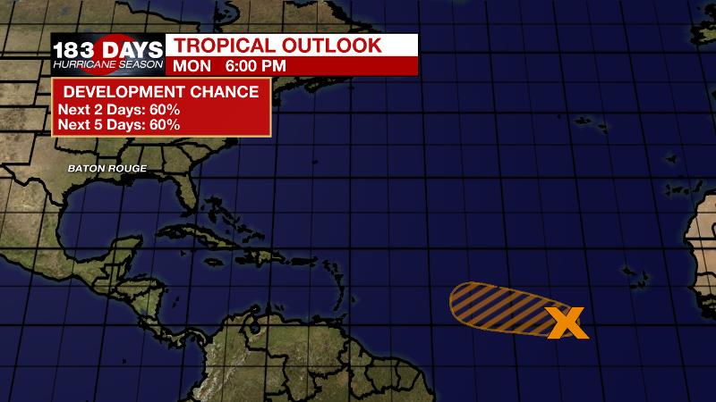
The Tropics: A broad area of low pressure midway between the Cabo Verde Islands and Lesser Antilles has had trouble organizing over the last 24 hours. Environmental conditions could become a bit more favorable for some organization as the system moves west-northwest across the central Atlantic and the National Hurricane Center gives it a 60 percent chance of formation over the next 5 days.
Trending News
The Explanation: An upper level ridge and slightly lower atmospheric moisture resulted in a relatively drier day across the forecast area. As we move into Tuesday, the ridge will be replaced with a shortwave trough of low pressure and slightly higher moisture. The result will be an gradual increase in the number of showers and thunderstorms that develop, each day through the week. The shortwave trough will create a weakness in the atmosphere that will merge with a wave moving east to west across the Gulf to form an inverted trough of low pressure. Cooler temperatures aloft will allow scattered to possible widespread showers and thunderstorms to develop Wednesday through Friday. Daytime warming and marine breezes will be the primary triggers for convection, followed by outflow boundaries as storms decay. Nights will be quieter, but muggy. The inverted trough will move away to the west on Saturday and the shower count should decline for the weekend into early next week. At this time, the Weather Prediction Center is highlighting a cold front approaching the region on Monday, while models suggest it stalls to our north. We will keep an eye on that feature for the days ahead.
--Josh
The WBRZ Weather Team is here for you, on every platform. Your weather updates can be found on News 2, wbrz.com, and the WBRZ WX App on your Apple or Android device. Follow WBRZ Weather on Facebook and Twitter for even more weather updates while you are on the go.
More News
