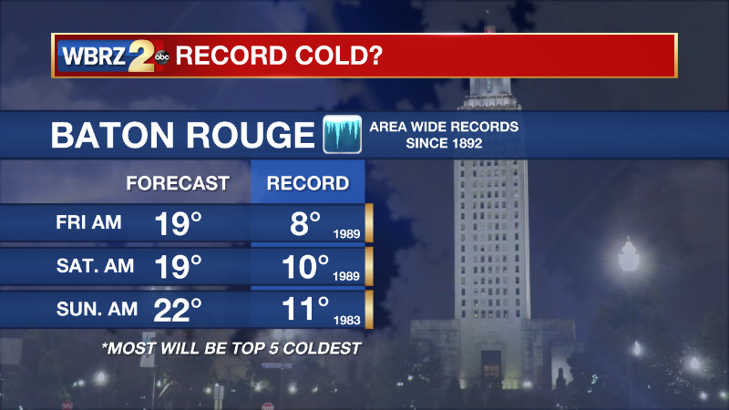
Friday AM Forecast: The Hard Freeze will last through Christmas
The cold temperatures will last through Christmas Day.
THE FORECAST
Today & Tonight: A wind chill advisory has been extended through the day today into Saturday morning because the wind chill will make temperatures feel like the teens even into the afternoon. No snow or ice has fallen, and none is in the forecast. The roads are safe to drive. Winds will be the main issue for us. I can’t say this enough, bundle up and stay warm. The hard freeze overnight with the air temperature near 20°.
*WIND CHILL ADVISORY* for the shaded area. Blustery winds may produce "feels-like" temperatures lower than 13°. Cover exposed skin, wear fitting layers. Our latest forecast: https://t.co/1NFYtqf6dL #lawx #mswx pic.twitter.com/g4D1ilw95m
— WBRZ Weather (@WBRZweather) December 22, 2022
*HARD FREEZE WARNING* for the shaded area. Temperatures are expected to drop below 25°. #lawx #mswx Our latest forecast: https://t.co/1NFYtqf6dL pic.twitter.com/eqnGXTKOw8
— WBRZ Weather (@WBRZweather) December 23, 2022Trending News
Up Next: The hard freeze conditions will last through the holiday weekend with the warning set to expire on Christmas morning. High temperatures on Saturday will be in the 30s, but we will briefly warm above freezing. On Christmas Eve night, temperatures will fall into the low 20s. Christmas morning will maintain those temperatures in the 20s too. Christmas Day afternoon, temperatures will be in the low 40s. Heading into Monday morning, temperatures will again be in the 20s. After that temperatures will start to rebound. Monday and Tuesday will bring high temperatures in the 50s with lows still in the 30s. Starting Wednesday, temperatures will be in the upper 60s and low 70s through the rest of the week. Click here to see the 7-day forecast.
Hour-by-hour weather tracking is available for your location on the WBRZ WX App on your Apple or Android device. Follow WBRZ Weather on Facebook and Twitter for even more weather updates and unique weather insight from the whole team!
(((Following Data courtesy of National Weather Service)))
Every event is different and should be treated as such, but for some modern reference, here are a few relatable cold outbreaks:
-February 2nd through 5th 1996
-January 8th through 11th 2010
-February 15th through 17th 2021.
This cold blast will likely be more potent than the 2021 event. However, IT WILL NOT be accompanied by significant wintry precipitation thereby eliminating the risk for ice induced power outages.

As for a reference to Christmas, surprisingly there are two relatable historic events:
-December 23rd through 26th 1983
-December 22nd through 25th 1989
These two were extreme events and at this time we are not expecting to test those records. The 1989 cold airmass still holds numerous records across a good portion of the United States including locally where single digits were recorded in many places. We would have to go back to 1899 to see temperatures recorded lower than 1989 in much of the area over a multi day stretch.


