

Latest Weather Blog
Friday AM Forecast: Flood Watch to expire tonight; Grab a raincoat this weekend
The National Weather Service has continued the FLASH FLOOD WATCH through this evening for all local parishes EXCEPT East Feliciana, Pointe Coupee and West Feliciana. Nicholas continues to slowly drift north and east in Louisiana with copious amounts of gulf moisture continuing to stream into the area. Additional rain amounts of 1 to 3 inches with locally higher amounts are possible over the next several days.
THE FORECAST
Today & Tonight: There is still a Flash Flood Watch out for the Baton Rouge area through this evening. Showers and storms will be scattered through the morning and afternoon hours today… again since the ground is already so saturated, it will not take much to cause isolated flooding problems. Continue to use caution on the roads especially when it is actively raining. All this rain will keep temperatures trending in the low to mid 80s with high humidity.
The Tangipahoa River at Robert is the only local river in flood stage. It is expected to crest at 18.5 feet tomorrow and will fall below flood stage in the middle of next week.
Up Next: We will be dodging showers and storms through the weekend. Saturday rain coverage will be more isolated. If you’re heading out to a football game, grab a raincoat just in case. Showers will be a bit more numerous on Sunday. Both weekend days will be muggy with temperatures maxing out in the mid-80s. Showers and storms will continue to be scattered through early next week. Since there will be so much available moisture skies will be mostly cloudy and showers will be able to pop up in the morning as well as the afternoon. Not all areas will see rain every day. Temperatures will continue to trend below normal in the mid-80s. Late next week some dry air will be moving south over the Midwest and it is forecast to reach the Gulf Coast by Thursday. This will offer a much needed dry out and come cooler temperatures. The WBRZ Weather team is tracking it closely. Click here to see the 7-day forecast.
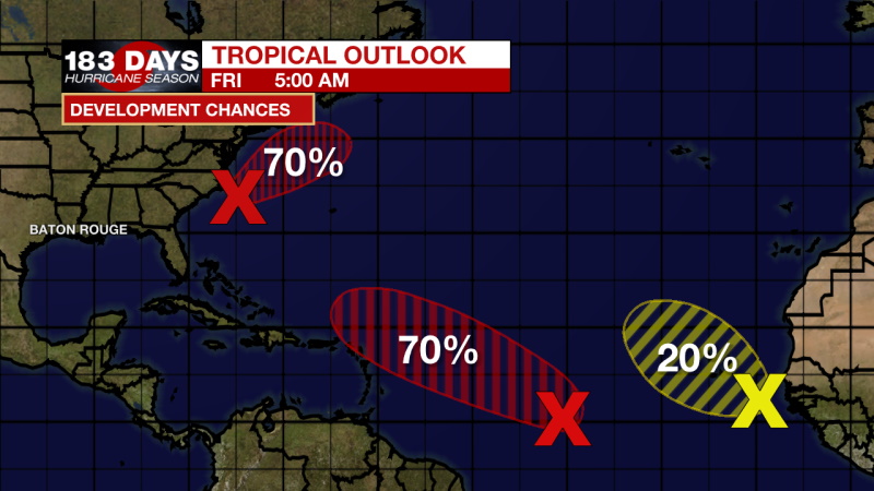
In the Tropics:
Trending News
Showers and thunderstorms remain disorganized in association with a tropical wave and broad area of low pressure located about 1100 miles west-southwest of the Cabo Verde Islands. However, environmental conditions are expected to be conducive for development during the next few days, and a tropical depression could still form over the weekend. This system is expected to move westward to west-northwestward at 15 to 20 mph across the tropical Atlantic during the next several days. There is a 70% chance of development over the next 5 days.
A broad area of low pressure is located about 100 miles southeast of the Outer Banks of North Carolina. Although the circulation of this system has become a little better defined since yesterday, the associated showers and thunderstorms remain disorganized and located mainly well to the east of the center. Environmental conditions are becoming more conducive for development, and a tropical depression is likely to form during the next day or so while the system moves northward to north-northeastward off the southeast and mid-Atlantic U.S. coasts. Regardless of development, this system could bring high surf to portions of the southeast and mid-Atlantic U.S. coasts through this weekend. Additional information on this system, including gale warnings, can be found in High Seas Forecasts issued by the NOAA Ocean Prediction Center. There is a 70% chance of development over the next 5 days.
Disorganized cloudiness and thunderstorms over the far eastern tropical Atlantic are associated with a tropical wave located a few hundred miles southeast of the Cabo Verde Islands. Environmental conditions are forecast to be only marginally conducive, and development, if any, of this system should be slow to occur over the next few days while the system moves west-northwestward to northwestward over the far eastern Atlantic. There is a 20% chance of development over the next 5 days.
The WBRZ Weather Team is watching the tropics around the clock and will bring you updates as they come. Click here to visit the Hurricane Center.
Reminder: With the threat for impactful weather—localized flooding—please have access to alerts through Saturday. You can download or activate the WBRZ WX App on your Apple or Android device or turn on a NOAA Weather Radio for bulletins such as watches and urgent warnings. Of course, WBRZ, WBRZ+ and the Cable Weather Channel will have updates as active weather dictates.
More News
