

Latest Weather Blog
Baton Rouge Wearin' Green, radar is not
The first legitimate severe weather threat of the season spared the Baton Rouge area on Friday morning. Quiet conditions have returned, and will stay a few days, before the next storm system.
Next 24 Hours: Overnight will be clear and cool with northwest winds of 5-10mph helping low temperatures into the mid 40s. Light north breezes will continue on Saturday with ample sunshine pushing high temperatures into the low 70s.
Wearin’ of the Green Parade: We have a “pot of gold” forecast as the 35th edition of this Baton Rouge institution rolls. With the 5k beginning around 8am, runners will be beneath clear skies but feeling a slight chill with temperatures right around 50 degrees. As the parade hits the streets at 10am, temperatures will be chugging along into the 60s. As floats disperse in the Perkins Road area around midday, skies will be mostly sunny with thermometers pushing on 70 degrees.
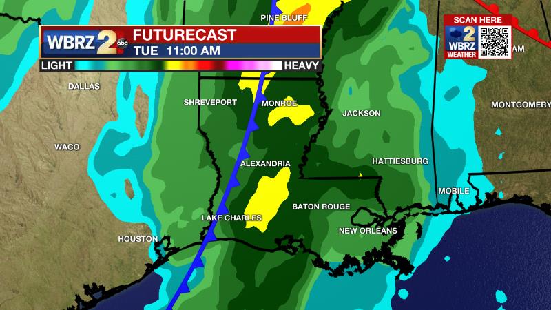
Up Next: Sunday morning will be rather chilly for the time of year with lows in the low 40s. Sunshine will quickly push afternoon highs in the low 70s. On Monday, highs will return to the upper 70s with sun disappearing behind increasing clouds late in the day. Another strong storm system will move across the Southeast U.S. on Tuesday and Wednesday. Thunderstorms are back in the forecast Tuesday and we will need to monitor the setup for severe weather. Additionally, a slightly slower moving nature of this system could also lead to a possibility for heavy as well. The latter half of next week looks quiet. CLICK HERE for your detailed 7-Day Forecast.
The Explanation: Much drier air will move into the region maintaining clear skies. A fast moving upper level disturbance will jet through on Saturday but with the cold front well offshore and the drier air in place, just a few thin clouds could develop. An upper level ridge will briefly build over the area on Sunday leading to more sunshine and slightly warmer afternoon temperatures. This ridge will quickly migrate east of the area on Monday and onshore flow will return moisture to the area Monday night.
Trending News
Attention will turn to the next upper level trough of low pressure and surface storm system. This upper level trough will be much deeper and more amplified with a slower moving surface storm. With some upper level disturbances possible moving through the east side of the upper trough before the associated cold front arrives, there could be multiple rounds of active weather late Monday through early Wednesday. The main period to key in on for a lot of action, as of now, appears to be Tuesday. The latest forecast model guidance checks off many of the boxes for severe weather including moisture, instability, strong low-level winds and even stronger upper level winds. Speaking to those very strong upper level winds which serve to maintain thunderstorms, when combined with very deep moisture in the atmosphere and the slow moving nature of this system, heavy rain could become a concern as well. By late Wednesday, a cold front should be east of the area with a surface high pressure system building in from the west through the end of the week and providing us with a period of quiet weather.
The Storm Station is here for you, on every platform. Your weather updates can be found on News 2, wbrz.com, and the WBRZ WX App on your Apple or Android device. Follow WBRZ Weather on Facebook and Twitter for even more weather updates while you are on the go.
More News
