

Latest Weather Blog
Wednesday Midday Video Forecast
Related Story
Wednesday remains quiet and dry but we will finish the week the same way we started, with a severe weather threat in the Capital Area. Following storms early Friday, your weekend will be sunny and quiet with an artic cold blast arriving early next week.
Today & Tonight: Wednesday morning low temperatures dipped into the 30s thanks to clear skies and calm winds. During the day today, expect plenty of sunshine with cool afternoon temperatures in the upper 50s. Overnight tonight, cloud coverage begins to increase as southerly flow allows an increase of moisture around southern Louisiana. Temperatures will be a bit more mild, in the mid-40s, to start off your Thursday morning.
Up Next: Despite the added cloud cover, Thursday will see temperatures near 70° ahead of our next storm system. While we can't rule out a spotty shower or two during the day, a warm front will sweep through the Capital Area late Thursday night allowing more widespread rain and storms. Overnight, a cold front will trail behind and allow for another round of showers and storms to pass through SE Louisiana right around your morning commute hours. With this system, the Storm Prediction Center has the Baton Rouge area and parishes north included in a 2/5 risk for severe weather. Similar to Monday's system, we cannot rule out a spin up tornado or damaging winds. Later today and tomorrow we will have more specifics on the threats and timing associated with Friday morning's system.
.png)
The cold front quickly sweeps showers and clouds out of the area by Friday evening. Dry conditions take over and the weekend is shaping up to be sunny but cool! Morning lows will hang around the freezing mark and afternoon temperatures will be in the mid to upper 50s Saturday and Sunday. Things turn even colder by the beginning of next week!
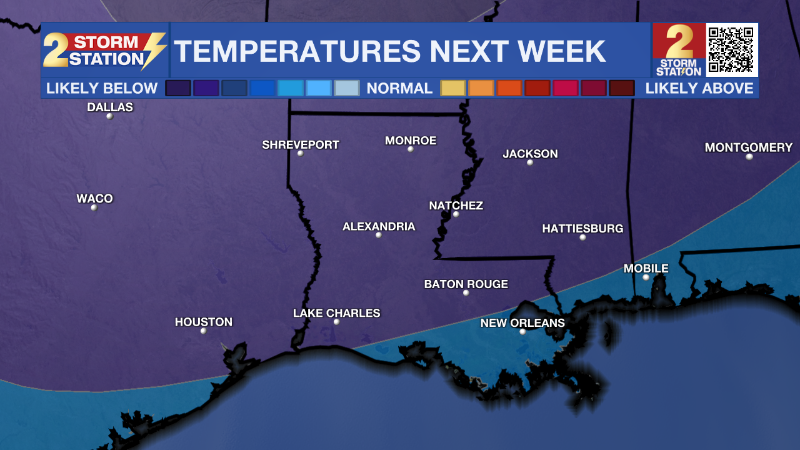
The Storm Station is tracking the coldest air of the season that is set to arrive during the day on Monday. At the same time, a batch of rain is expected to move across the central Gulf Coast. There is a possibility that some frozen precipitation mixes in toward the end of the event if enough moisture coincides with the tumbling temperatures. While it is much too early to speculate on frozen precipitation or ice potential after the rain, there is high confidence that the coldest air of the season will take over the region. Beginning early Tuesday, we could spend several hours in the mid to upper 20s so plan for hard freezes, taking the necessary precautions on pipes and other home infrastructure this weekend.
Get the latest 7-day forecast and real time weather updates HERE.
Watch live news HERE.
– Emma Kate Cowan
The Storm Station is here for you, on every platform. Your weather updates can be found on News 2, wbrz.com, and the WBRZ WX App on your Apple or Android device. Follow WBRZ Weather on Facebook and Twitter for even more weather updates while you are on the go.
News
