

Latest Weather Blog
Wednesday evening video forecast
Related Story
The rest of the workweek will be quite mild with a few rounds of showers and thunderstorms. The same general pattern will continue into the weekend until a cold front pushes through on Sunday.
Tonight & Tomorrow: Clouds that thickened through the day will be persistent overnight. As low temperatures stop in the upper 60s, southeast winds from the Gulf of Mexico and the lakes could result in some patchy fog moving around. Similar weather is expected on Thursday. A lot of cloud cover is expected with an occasional glimpse of sunshine. An isolated shower or thunderstorm is possible during the afternoon hours. Running about 10 degrees above average, high temperatures will top out in the mid 80s.
Up Next: For the remainder of the workweek and through at least Saturday, temperatures will be a few degrees above average. Expect morning lows in the upper 60s and afternoon highs in the low to mid 80s.
By Friday, a slow moving cold front will move into the region, increasing showers and thunderstorms even further. In fact, the final day of the workweek will likely feature the highest coverage of rain across the Capital Area. Any thunderstorms will be capable of producing heavy rain and gusty wind, potentially snarling traffic at times. The late morning to late afternoon period looks most active.
The cold front is expected to stall over the region Saturday maintaining the potential for isolated showers and thunderstorms. While there may be a lull during the morning hours, as daytime warming takes over, some activity could flare up into the afternoon. There will be plenty of energy in the atmosphere to support thunderstorms. With several outdoor events slated for the weekend, it will be important to keep tabs on the Storm Station forecast, especially with regard to any possibility of lightning. Have an indoor contingency nearby in the event of a thunderstorm. Of the two weekend days, Saturday is expected to have more dry time and warmer temperatures.
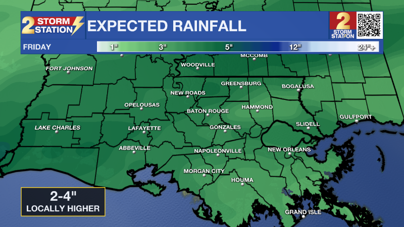
The cold front is expected to get a significant push south later Sunday. A final batch of rain and thunderstorms will press through. By the time rain wraps up, a 5-day total of about 2-4" is expected. Prepare for a substantial drop in temperatures into the beginning of next week. Thermometers will be several degrees below average which is mid 70s over low 50s for the time of year. Some more lows in the 40s are likely.
Get the latest 7-day forecast and real time weather updates HERE.
Watch live news HERE.
– Josh
The Storm Station is here for you, on every platform. Your weather updates can be found on News 2, wbrz.com, and the WBRZ WX App on your Apple or Android device. Follow WBRZ Weather on Facebook and Twitter for even more weather updates while you are on the go.
News
