

Latest Weather Blog
Wednesday evening video forecast
Related Story
Humidity will begin to creep back up over the next several days. Despite this uptick in moisture, rain will remain hard to find.
Tonight & Tomorrow: Another night of mostly clear skies is ahead. Though slightly warmer than previous nights, low temperatures may just break the 70 degree barrier one more time along and north of I-12. Thursday will be partly sunny and warm with high temperatures running into the low and mid 90s. A few more clouds will bubble up as compared to previous afternoons.
Up Next: Friday and into the weekend, humidity will begin to increase but not return to peak summer levels. Without a ton of humidity and no major storm systems passing through, it is hard to justify anything more than a ten percent rain chance, and that will primarily be near the coast where better moisture resides. Early next week, there are some early signs that a weak cold front will approach the area. Enough moisture will arrive ahead of this feature to support a shower or thunderstorm. Even with the front, dry and warm is the ongoing weather theme.
Get the latest 7-day forecast and real time weather updates HERE.
Watch live news HERE.
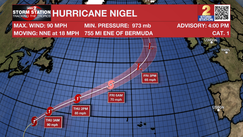
The Tropics: Hurricane Nigel continues to move north over the central Atlantic Ocean at 18mph with maximum sustained winds of 90mph. Nigel will turn northeast and accelerate through the rest of the week with a decrease in strength and the storm will turn post-tropical by the end of the week.
A tropical wave is currently located a couple of hundred miles southeast of the Cabo Verde Islands. This system is expected to merge with another disturbance located a few hundred miles to its west in a few days. Environmental conditions are forecast to be conducive for gradual development, and a there is a seventy percent chance that a tropical depression will form late this week or this weekend while the system moves generally westward at 10 to 15 mph across the eastern and central tropical Atlantic.
A non-tropical low pressure system is expected to form within a large area of disorganized showers and thunderstorms to the east of the Florida peninsula within the next day or two. There is a forty percent chance that this system could acquire some subtropical characteristics on Friday while it moves generally northward. Regardless of development, this low is likely to bring gusty winds to gale force, heavy rain, and high surf to portions of the Southeast and Mid-Atlantic United States late this week and into this weekend.
– Josh
The Storm Station is here for you, on every platform. Your weather updates can be found on News 2, wbrz.com, and the WBRZ WX App on your Apple or Android device. Follow WBRZ Weather on Facebook and Twitter for even more weather updates while you are on the go.
News
