

Latest Weather Blog
Wednesday Evening Video Forecast
Related Story
Look for the well above average temperatures and low end afternoon rain chance to continue. A weak cold front will try to bring in some drier air by the second half of the weekend.
A *HEAT ADVISORY* will be in effect on Thursday from 11am to 7pm across the entire viewing area. Feels-like temperatures could be as high as 108 to 112 expected.
Drink plenty of fluids, stay in an air-conditioned room, stay out of the sun, and check up on relatives and neighbors. Young children and pets should never be left unattended in vehicles under any circumstances.
Take extra precautions if you work or spend time outside. When possible reschedule strenuous activities to early morning or evening. Know the signs and symptoms of heat exhaustion and heat stroke. Wear lightweight and loose fitting clothing when possible. To reduce risk during outdoor work, the Occupational Safety and Health Administration recommends scheduling frequent rest breaks in shaded or air conditioned environments. Anyone overcome by heat should be moved to a cool and shaded location.
Tonight & Tomorrow: Just like previous days, a few showers flared up in response to daytime warmth. They will fall apart shortly after nightfall. Low temperatures will drift into the mid 70s. Thursday will be rather hot. High temperatures will find their way into the upper 90s below mainly sunny skies. Like every day this week, a rogue shower or thunderstorm could pop.
Up Next: After another afternoon in the upper 90s, a weak front will dive south into the area later Friday. This front is expected to stir up a few showers and thunderstorms in the evening hours and could remain close enough to trigger some isolated activity on Saturday as well—especially closer to the coast. Looking at those first tailgates in Baton Rouge on Saturday, be prepared for a passing shower or thunderstorm, but there are no indications of a washout. Otherwise, it will be very warm and humid with morning temperatures in the mid 70s rising into the low 90s by afternoon. Changes on the other side of the front will be minimal, but there could be a little lower humidity for the second half of the weekend. It will be most noticeable on Sunday and Monday mornings with lows in the low 70s.
Get the latest 7-day forecast and real time weather updates HERE.
Watch live news HERE.
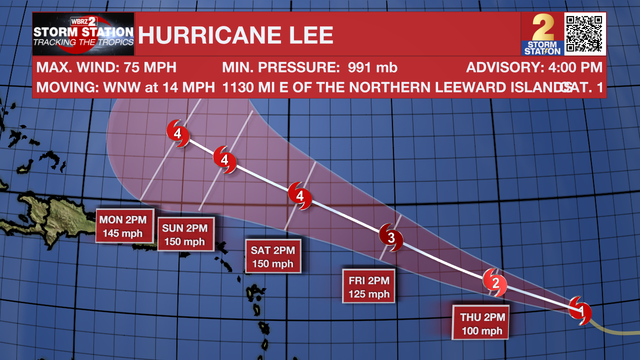
The Tropics: Hurricane Lee will continue to rapidly intensify and is expected to be a powerful and dangerous hurricane by the weekend. With maximum winds now over hurricane strength, the storm continues barreling westward at 15mph. This same general speed and motion is expected through the week with high swells becoming an issue near the Lesser Antilles.
A tropical wave is producing a large area of disorganized showers and thunderstorms over the far eastern Atlantic between the Cabo Verde Islands and the west coast of Africa. Environmental conditions appear conducive for some gradual development of this system, and there is a sixty percent chance that a tropical depression could form later this week or this weekend while the system moves west northwestward at 10 to 15 mph over the eastern tropical Atlantic.
Shower and thunderstorm activity associated with Post-Tropical Cyclone Franklin, located a few hundred miles east-northeast of the Azores, has become a little better organized today. Although environmental conditions are only marginally favorable for additional development this system could briefly acquire some subtropical or tropical characteristics during the next day or so, while it moves northeastward or northward over the northeastern Atlantic. By Friday, further development is not expected as the system is forecast to move into unfavorable environmental conditions, which should cause it to weaken.
--Josh
The Storm Station is here for you, on every platform. Your weather updates can be found on News 2, wbrz.com, and the WBRZ WX App on your Apple or Android device. Follow WBRZ Weather on Facebook and Twitter for even more weather updates while you are on the go.
News
