

Latest Weather Blog
Wednesday evening video forecast
Related Story
While no more records fell on Wednesday, temperatures remained well above average. A strong cold front will being a big swing on thermometers into the weekend.
Next 24 Hours: Continued advance of drier air will take humidity down enough overnight for low temperatures to fall into the low 50s beneath mostly clear skies. On the perimeter of Tropical Storm Nicole, we may see some high clouds and feel a north breeze of 5-10mph on Thursday. Otherwise, a good deal of sunshine will warm temperatures into the upper 70s.
Up Next: On Friday, a strong cold front will move into the area. North winds behind it will bring on a substantial temperature drop heading into the weekend as thermometers reach the low 50s by dawn Saturday. The front itself will be starved of moisture making any rainfall ahead of it unlikely. Moisture on the back side could result in a stray shower early Saturday and will cause clouds to linger for most of the day therefore keeping afternoon readings near 60. Clearing skies and the ongoing north winds will send low temperatures tumbling into the 30s on Sunday morning. After a cool and quiet finish to the weekend, we are watching a system that could bring a chilly rain Monday into Tuesday of next week. CLICK HERE for your detailed 7-Day Forecast.
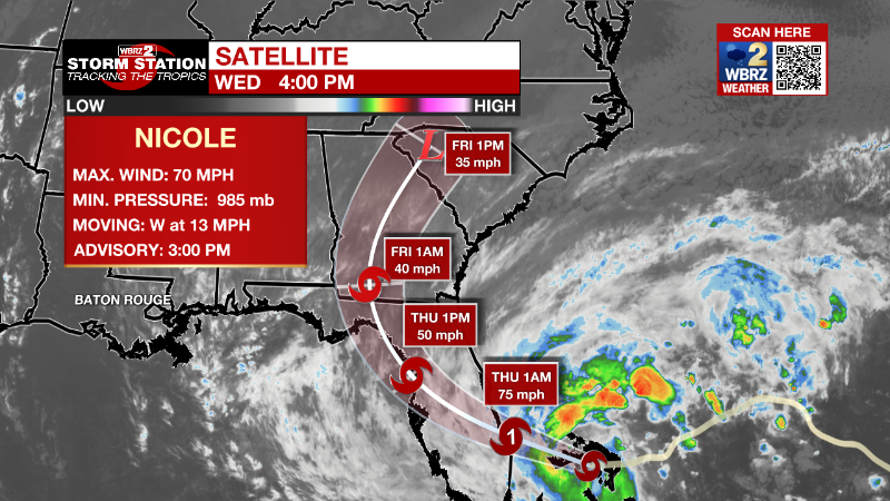
The Tropics: Tropical Storm Nicole is moving west across the Bahamas at 13mph with maximum sustained winds of 70mph. The storm will jog northwest overnight and is expected make landfall in Florida overnight as a hurricane. Nicole will then move across north Florida into Georgia and reach the Carolinas as a post-tropical system Friday. This large system has storm force winds extending 485 miles outward from center. In addition to wind related power outages, up to five feet or surge is expected across parts of the Florida coast in addition to 3-5 inches across parts of the Southeast U.S.
The Explanation: Nicole will not have any significant impact on the local weather other than potentially adding a slight breeze and some thin clouds on Thursday. Northeast winds have started to push the more muggy air south and with lower dew points, overnight low temperatures will end up much lower than previous nights into Thursday and even Friday. Starting lower, thermometers will have too far to go to be as warm as earlier in the week as well. A strong, upper level trough of low pressure will move across the Eastern U.S. on Friday dragging an associated cold front into the local area. Moisture will not increase enough for significant rain, but the front could squeeze out a light shower or two overnight Friday into Saturday. Until the center of the trough pushes east, clouds will be stubborn to break and this could take most of Saturday. Much cooler air will spill into the region dropping temperatures as good 15-20 degrees from current levels and putting them ultimately about 10 degrees below average. Overnight low temperatures will find the 30s in most neighborhoods north of I-10 for several days Sunday into next week.
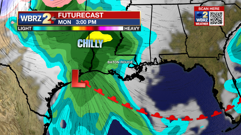
After a quiet Sunday, the next upper level trough will cause a surface low to form at the tail end of the cold front near south Texas. This system will track northeastward across the Gulf of Mexico delivering a shield of rain to the central Gulf Coast late Monday into Tuesday. The exact position of the low will determine if the area can warm into the 60s, if it crosses inland, or has a chilly and rainy day if it stays over water.
--Josh
The Storm Station is here for you, on every platform. Your weather updates can be found on News 2, wbrz.com, and the WBRZ WX App on your Apple or Android device. Follow WBRZ Weather on Facebook and Twitter for even more weather updates while you are on the go.
News
