

Latest Weather Blog
Wednesday evening video forecast
Related Story
Quiet weather will continue through Thursday. The next storm system will deliver a period of off and on rain into the beginning of the weekend.
Next 24 Hours: Skies will remain clear overnight with light, northerly winds helping to guide low temperatures into the upper 40s once again. Other than some high clouds, Thursday will be another mainly sunny afternoon with high temperatures finding the upper 70s.
Up Next: A developing storm system over Texas will spread clouds into the area through Friday. Temperatures will not warm much more than the mid 70s as clouds cut off sunshine. By the second half of the day, showers will develop from west to east. Some high school football games could turn out to be damp. A cold front will continue to bring showers and possibly a few thunderstorms to the area overnight. Rain will taper through Saturday, but at least some clouds could linger into Sunday. Temperatures will remain closer to average beyond that system into early next week. Dry weather is anticipated for Halloween and trick-or-treating. CLICK HERE for your detailed 7-Day Forecast.
#Halloween is looking fine in the #BatonRouge area this year. The map below shows what happened back in 2015. Here is some more Oct. 31 climatology: https://t.co/tl5UhdsUSb pic.twitter.com/abdcfGgXfQ
— Josh Eachus (@DrJoshWX) October 26, 2022
The Tropics: A trough of low pressure stretching from the eastern Caribbean northward to the southwestern Atlantic continues to produce a broad area of disorganized showers and thunderstorms. Environmental conditions support a fifty percent chance of subtropical development as it drifts northward during the next couple of days. The system is then forecast to meander over the subtropical western Atlantic to the west or southwest of Bermuda. Upper-level winds are forecast to become less conducive for development by the end of the weekend.
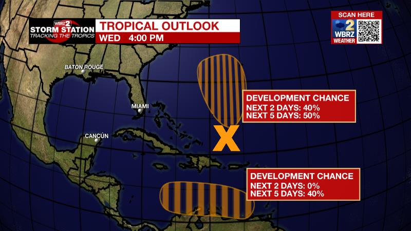
An area of low pressure is expected to form over the eastern Caribbean Sea this weekend. Environmental conditions are forecast to be conducive for gradual development, and there is a forty percent chance that a tropical depression could form by early next week while the disturbance moves generally westward or west-northwestward over the central Caribbean Sea.
The Explanation: Winds will stay out of the north into Thursday. Dry air will maintain low humidity and clear skies leading to diurnal temperature ranges of 25 to 30 degrees. These readings are about 5 degrees below average for the time of year. A strong upper level trough of low pressure will move across central Texas and into the Arklatex region Friday night into Saturday. A strengthening surface low pressure system and associated fronts will be draped across the Texas coastal area on Friday night before quickly translating to the northeast. With deep moisture moving in ahead of the system along with broad lift, showers will develop as the workweek ends. The low will reach I-20 by Saturday morning, pulling a cold front through the local area. Instability is expected to be too limited for severe weather, but some rumbles of thunder are possible as the front sweeps east. By Saturday afternoon, dry air to overtake the region behind that front, and moisture will be cut off, effectively ending the threat for organized precipitation.
--Josh
The Storm Station is here for you, on every platform. Your weather updates can be found on News 2, wbrz.com, and the WBRZ WX App on your Apple or Android device. Follow WBRZ Weather on Facebook and Twitter for even more weather updates while you are on the go.
News
