

Latest Weather Blog
Wednesday evening video forecast
Related Story
The chance for showers and thunderstorms will end by Thursday morning. Not much change in temperatures is expected from the front currently progressing through the area, but a significant dip is coming next week.
Next 24 Hours: A weakening cold front will push through the area overnight with a broken line of showers and thunderstorms accompanying it. The front and associated precipitation will come in late so low temperatures will stay mild in the mid to upper 60s thanks to southeast winds of 5mph and mostly cloudy skies. Showers will end from northwest to southeast around dawn Thursday with clearing through late morning. Skies will be mostly sunny in the afternoon with high temperatures in the mid 80s.
Up Next: Dry conditions will persist through Friday and Saturday with slightly above average temperatures—with highs in the mid 80s and lows in the upper 50s and low 60s. A much stronger cold front will blow into the region Sunday into Monday. This system will provide another chance for showers and thunderstorms for the end of the weekend and the beginning of next week and bring the coolest temperatures so far this fall season. Expect high temperatures in the low 70s and low temperatures in the mid 40s next week. CLICK HERE for your detailed 7-Day Forecast.
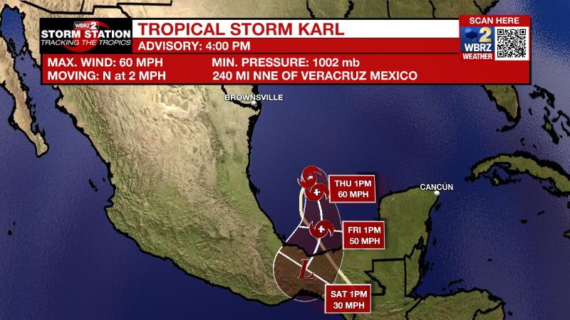
The Tropics: Tropical Storm Karl was strengthening in the extreme southern Gulf of Mexico on Wednesday afternoon with maximum sustained winds of 60mph and a movement to the north at 3mph. Karl will turn back to the south overnight and pick up speed with gradual weakening until landfall in Mexico on Friday.
The Explanation: An upper level trough of low pressure and associated cold front over the Lower Midwest will approach the area tonight. These features should help to lead in a broad line of showers and a few embedded thunderstorms. Activity will quickly diminish around dawn from north to south. The next few days will likely remain dry as inland dew point temperatures trail off into the 50s behind the cold front. However, winds will switch around to the south allowing moisture to get involved once again over the weekend. Expect low temperatures in the 60s with some high clouds developing again as early as Saturday. A deep, upper level trough of low pressure will start to build into the Eastern U.S. Sunday. This trough will drive another front into the area on Sunday. Since onshore flow will have already started moisture return, a couple of showers and thunderstorms will be possible with this system Sunday into Monday followed by another frontal passage.
The depth of the colder air mass looks much more significant with this front. High temperatures are expected to be in the upper 60s to mid 70s Tuesday through the middle of next week. Low temperatures will reach their coldest marks so far this fall with some spots hitting the mid 40s.
--Josh
The Storm Station is here for you, on every platform. Your weather updates can be found on News 2, wbrz.com, and the WBRZ WX App on your Apple or Android device. Follow WBRZ Weather on Facebook and Twitter for even more weather updates while you are on the go.
News
