

Latest Weather Blog
Wednesday evening video forecast
Related Story
The week will end with scattered showers and thunderstorms. High temperatures will stay below average.
Next 24 Hours: Decaying showers and thunderstorms will slowly drift south and offshore into the evening hours. Some clouds will linger into the night with low temperatures very near the seasonal average of 71 degrees. Thursday will not be quite as nice as much of Wednesday. Conditions will vary across the area due to the position of a storm system right on top of us. In general, more clouds and showers are expected from Baton Rouge and locations to the south and east with more dry time north and west. Therefore, high temperatures will range from the mid 80s in those sections with more clouds to the upper 80s where some more sun peeks through.
Up Next: Friday and Saturday will bring more damp conditions with mostly cloudy skies and occasional showers and thunderstorms. Neither day looks like a total washout. The struggle for sunshine will cause below average high temperatures in the mid 80s. For Tigers and Jags fans, the forecast is not perfect but by no means will weather ruin the day. By Sunday, some drier air is expected to filter into the region helping to break apart clouds and lower daily rain coverage. On Monday, a weak front will push through the region. The upper levels will have already dried making showers and thunderstorms a bit more scarce than recently. Once the front passes, surface air will dry a bit too resulting in just slightly lower humidity and possibly lows in the upper 60s. CLICK HERE for your detailed 7-Day Forecast.
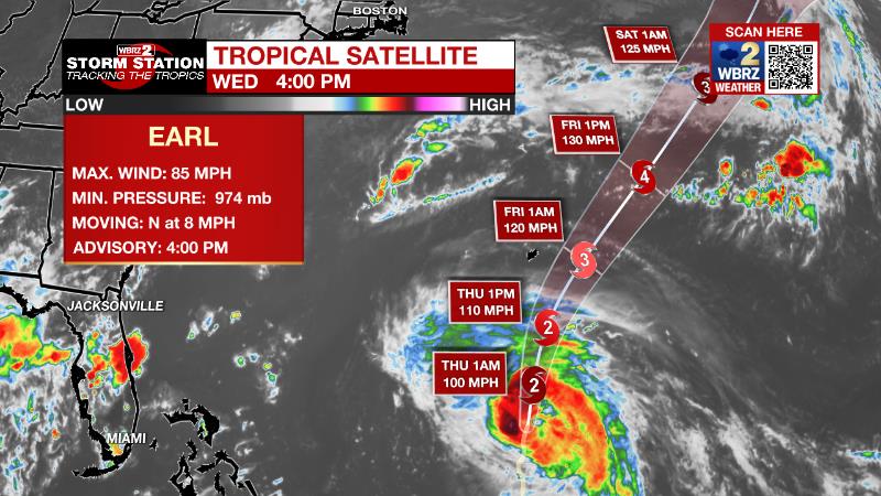
The Tropics: Hurricane Earl is located over 400 miles south of Bermuda and moving north at 8mph with 85mph winds. The storm is expected to become a major hurricane over the next day. Earl is expected to turn northeast and miss Bermuda to the east but will still produce tropical storm conditions there. Some swells could reach as far as the East Coast of the United States.
Hurricane Danielle remains a large storm generating massive swells up to 350 miles outward from its center in the north Atlantic Ocean. The storm has been producing maximum sustained winds of 80mph but is expected to weaken gradually as it accelerates eastward in the coming days.
Satellite imagery indicates that the area of low pressure located several hundred miles west of the Cabo Verde Islands is gradually becoming better defined. However, the associated shower and thunderstorm activity remains disorganized. Environmental conditions provide a seventy percent chance that a tropical depression forms by Friday while it moves westward to west-northwestward at 15 to 20 mph over the eastern and central tropical Atlantic.
A tropical wave currently located near the west African coast is forecast to emerge offshore into the eastern Atlantic over the next day or so. Environmental conditions will eventually allow a thirty percent chance of development as the system moves west-northwestward over the eastern tropical Atlantic.
The Explanation: The weak upper level trough that has been responsible for the last few days of clouds, showers and thunderstorms, will close off into an upper level low on Thursday and Friday. The exact position of this low along the central Gulf Coast will be crucial as to how the weather unfolds. Locations on the northern and eastern side of the low will receive more clouds and precipitation while southern and western spots will be drier. As of now, the Baton Rouge area looks like it will reside on the northwestern flank of the upper level low. This will lead to more clouds and precipitation for areas south and east of the city with less north and west. The annoying low will finally be able to release northeastward on Saturday slightly reducing convective activity around the area. Another shortwave trough of low pressure will move from the Midwest into the Great Lakes region early next week. At the surface a weak low will lead the parent upper level system with a trailing cold front at the surface. This front is expected to extend and crawl southward into our area losing most of its identity along the way. However, some drier air aloft and at the surface (in the form of lower dew points) may start to filter into the region by Tuesday. As a result, even though afternoons will stay warm, morning low temperatures could get into the upper 60s. All of this is climatologically plausible for the time of year.
--Josh
The Storm Station is here for you, on every platform. Your weather updates can be found on News 2, wbrz.com, and the WBRZ WX App on your Apple or Android device. Follow WBRZ Weather on Facebook and Twitter for even more weather updates while you are on the go.
News
