

Latest Weather Blog
Wednesday evening video forecast
Related Story
A weak front will settle near the Louisiana Coast leading to fewer showers and thunderstorms on Thursday. Deep, tropical moisture will usher in another wet pattern Friday and beyond.
Next 24 Hours: A front will fall apart near the coast overnight. Skies will clear out and low temperatures will stop in the low to mid 70s. On Thursday, drier air aloft will result in most inland locations getting a day without rain. Ample sunshine will boost high temperatures into the mid 90s. You might sense slightly lower humidity north of I-12, but the heat will make that hard to appreciate.
Up Next: Moisture from the Gulf of Mexico will surge right back into the area on Friday and scattered to widespread showers and thunderstorms are anticipated both weekend days. The return of more rain and more clouds will limit high temperatures to the upper 80s, which is only three, or four degrees below average for early September. Higher rain coverage with slow moving thunderstorms for a few consecutive days could again heighten the concerns for street and poor drainage flooding. CLICK HERE for your detailed 7-Day Forecast.
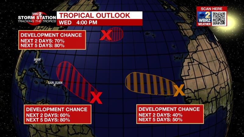
The Tropics: Data from a NOAA aircraft reconnaissance mission earlier today showed little change in organization of the area of low pressure located several hundred miles east of the Lesser Antilles. Although environmental conditions are only marginally conducive, additional gradual development of this system is expected and there is an eighty percent chance that a tropical depression forms within the next couple of days. The disturbance is forecast to move slowly west-northwestward, toward the adjacent waters of the northern Leeward Islands.
Showers and thunderstorms associated with a broad area of low pressure located just to the northeast of the Cabo Verde Islands have changed little since earlier today. Some gradual development is possible, and there is a fifty percent chance that a short-lived tropical depression forms over the far eastern Atlantic during the next couple of days. By late this week, environmental conditions are forecast to become increasingly unfavorable for further development.
An area of low pressure is showing signs of organization over the central subtropical Atlantic about 850 miles west-southwest of the westernmost Azores. Environmental conditions are expected to be conducive for development, and there is an eighty percent chance that a tropical or subtropical depression forms within the next day or so, while the system drifts generally eastward.
The Explanation: A weak surface front snuck into the area on Wednesday with some drier air penetrating into the upper levels of the atmosphere from I-10 northward. This drier air will remain in place through Thursday making it harder for showers and thunderstorms to develop. Convection may not be absent, especially near the coast, but most will stay dry. On the flip side, that drier air could help to invigorate a few downbursts and cause gusty winds in storms that can get going. At the surface, this drier air may be felt on Thursday afternoon in the form of dew points in the mid 60s. The deep dry air in the atmosphere coupled with surface heating should result in the surface layer mixing out and drying a touch as well. However, since drier air warms more efficiently, high temperatures will charge into the middle 90s. The front responsible for the drier air will retreat north and stall Friday into the upcoming weekend. Deep, tropical moisture will fill in behind it retu8rning a wetter pattern. Overall, average warm season weather is expected with scattered to widespread showers and thunderstorms breaking out with daytime warming. This will be the drill through at least Tuesday.
--Josh
The Storm Station is here for you, on every platform. Your weather updates can be found on News 2, wbrz.com, and the WBRZ WX App on your Apple or Android device. Follow WBRZ Weather on Facebook and Twitter for even more weather updates while you are on the go.
News
