

Latest Weather Blog
Tuesday Evening Video Forecast
Related Story
The drier and more comfortable air has been replaced by familiar humidity. A weak front will drift into the area and act as a culprit for some showers and thunderstorms through the rest of the week.
Tonight & Tomorrow: Any remaining showers or cloud cover will diminish by midnight. Low temperatures will bottom out in the low 70s—feeling a bit more muggy compared to previous nights. A weak disturbance in the atmosphere and its associated front will move into the area on Tuesday. After a partly sunny beginning to the day, this system will stir up isolated showers and thunderstorms, especially during the afternoon hours. High temperatures will make it into the low to mid 90s ahead of any precipitation.
Up Next: Through the end of the workweek, a decaying front will meander near the Gulf Coast. Though no single day looks particularly busy, the front warrants mention of a spotty, afternoon shower or thunderstorm. Coastal areas stand the best chance to see some rain. Otherwise, expect partly sunny skies with highs in the low 90s and lows in the low 70s. Another front will push in for the weekend and should bring a better shot at showers and thunderstorms on Saturday. Dry air tailing this front will bring another pop of lower humidity! In fact, there is a chance we could register our first high temperature in the 80s since May 27.
Get the latest 7-day forecast and real time weather updates HERE.
Watch live news HERE.
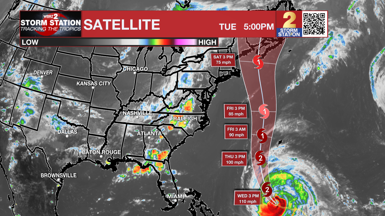
The Tropics: Hurricane Lee remains a major hurricane in the southwest Atlantic Ocean. The storm will take more of a northerly turn on Thursday and increase in forward speed. Although the center will likely pass west of Bermuda, the hurricane and tropical storm force winds have a far reach. Tropical Storm Watches are in place for Bermuda as of Tuesday afternoon. Dangerous surf is expected all across the Eastern Seaboard. Lee will then near New England closer to Saturday, gradually weakening as it approaches.
Hurricane Margot continues to chug north across the eastern Atlantic Ocean at 14mph. With maximum sustained winds of 80mph, the storm will maintain a similar intensity over the next several days while drifting northward. An erratic motion is expected into the weekend with large swells affecting The Azores.
A broad area of low pressure over the eastern tropical Atlantic continues to produce disorganized showers and thunderstorms. This system is expected to consolidate, with a low on the western side becoming dominant over the next day or two. Gradual development of the low is expected after that, and there is an eighty percent chance that a tropical depression is likely to form by this weekend while the system moves west-northwestward or northwestward at about 15 mph across the central tropical Atlantic.
--Josh
The Storm Station is here for you, on every platform. Your weather updates can be found on News 2, wbrz.com, and the WBRZ WX App on your Apple or Android device. Follow WBRZ Weather on Facebook and Twitter for even more weather updates while you are on the go.
News
