

Latest Weather Blog
Tuesday evening video forecast
Related Story
Clouds will exit east through Wednesday setting up a run of warmer afternoons. The next storm system could deliver some wet weather this weekend.
Next 24 Hours: The high cloud deck will start to thin out overnight, possibly allowing one last morning to nip the upper 50s. Much more sun will be available on Wednesday guiding high temperatures into the low 80s.
Up Next: Thursday and Friday will be mostly sunny with highs in the low to mid 80s—about 5-8 degrees above average for the time of year. Nights will be noticeably more muggy with lows in the low to mid 60s. A weakening cold front will approach the area Saturday.
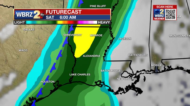
The exact speed and track of the system will determine if, and at what point, some showers and thunderstorms work into the area. As of now, the idea is that a broken line of showers will move in on Saturday morning. With the front stalling and falling apart over the area, scattered showers may linger through Saturday night and even into Sunday. While neither day is pegged as a washout, we will likely be dodging rain at times. CLICK HERE for your detailed 7-Day Forecast.
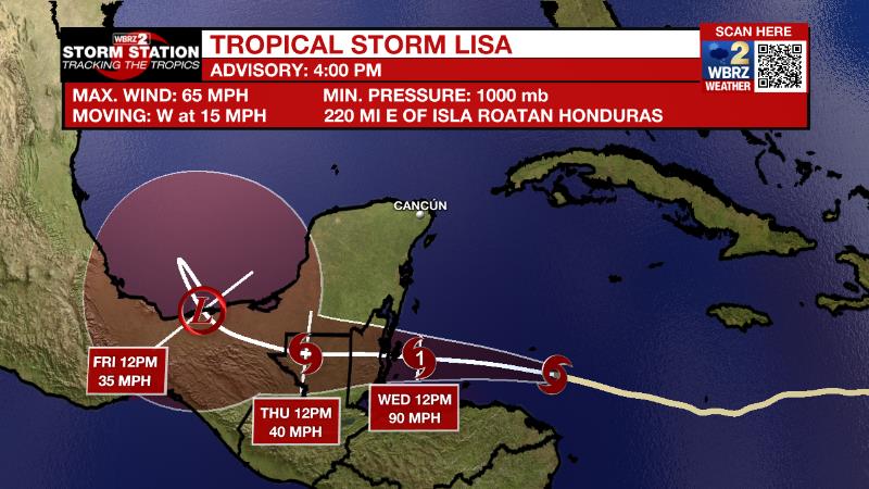
The Tropics: Tropical Storm Lisa is moving west across the Caribbean Sea at 15mph with 65mph and will rapidly intensify overnight. A slight decrease in forward speed is expected before making landfall as a category one, or possible category two, hurricane in Belize on Wednesday night.
Tropical Storm Martin is moving east across the north central Atlantic Ocean with maximum sustained winds of 60mph. Martin is expected to become a large hurricane but remain over open water before losing tropical characteristics later this week.
The Explanation: By Wednesday, an upper level trough of low pressure will be weakening and drifting east of the area as an upper level ridge of high pressure expands over the Gulf Coast. This sturdy ridge will continue the overall drier pattern that we've grown used to this autumn. Additionally, in response to the ridge, subsidence will cause above average temperatures with highs in the 80s and lows in the 60s through the weekend. The end of the forecast gets a bit more challenging and interesting. A sharp upper level trough of low pressure will cut out of the Mid-South into the Ohio Valley. Substantial moisture is expected to be in place across the area with plenty of warmth at the surface. The track of the upper level trough will determine if there is enough cooler air aloft and therefore instability, and a trigger for showers and thunderstorms. If the trough moves farther north as currently expected, a batch of weakening showers and thunderstorms will move into the area on Saturday. Any farther south and a threat for severe weather could materialize. The front will fall apart over the area with some lingering showers Sunday and then the warmer pattern with drier conditions will resume early next week.
--Josh
The Storm Station is here for you, on every platform. Your weather updates can be found on News 2, wbrz.com, and the WBRZ WX App on your Apple or Android device. Follow WBRZ Weather on Facebook and Twitter for even more weather updates while you are on the go.
News
