

Latest Weather Blog
Tuesday evening video forecast
Related Story
On Tuesday morning, temperatures dropped below 65 degrees for the first time since May 29. A few more mornings in the 60s are ahead.
Next 24 Hours: A second consecutive comfortable night is ahead. Low temperatures will settle around 63 degrees beneath mostly clear skies. Humidity will remain low on Wednesday. High temperatures will warm to 88 degrees in response to a lot of sun.
Up Next: By Thursday and Friday, high temperatures will challenge the 90s again. Still, not much will be happening in skies. Over the weekend, an onshore wind direction should return some moisture, low temperatures in the 70s and possibly isolated showers for locations closer to the coast. These small rain chances will quickly diminish again early next week with a bout of warmth and late season humidity. Overall, many locations should stay dry through next Tuesday. CLICK HERE for your detailed 7-Day Forecast.
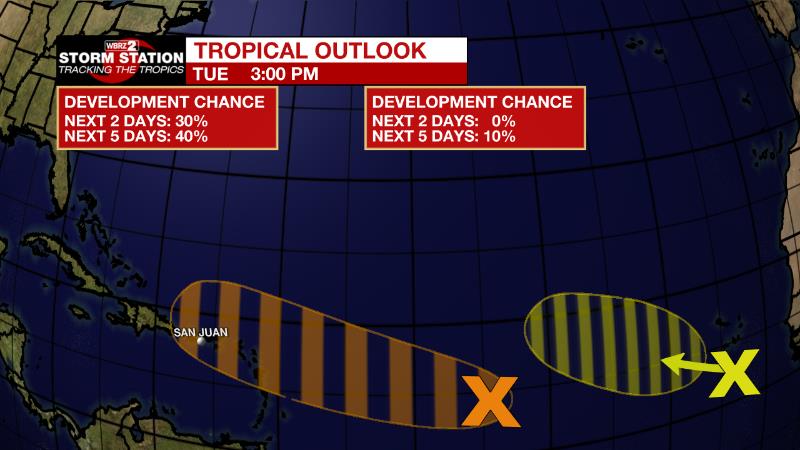
The Tropics: Showers and thunderstorms associated with a tropical wave located about 1000 miles east of the Lesser Antilles have changed little in organization since this morning. Although environmental conditions are only marginally conducive, there is a forty percent chance of gradual development over the next few days. A tropical depression could form while the system moves westward to west-northwestward over the tropical Atlantic and approaches the Leeward Islands on Friday.
Showers and thunderstorms associated with a tropical wave passing near the Cabo Verde Islands have diminished and become more limited today. Environmental conditions are forecast to remain only marginally favorable during the next several days, and the chance for development is down to ten percent as it moves west-northwestward across the eastern and central tropical Atlantic through the end of the week.
The Explanation: The axis of an upper level low over the Northeast U.S. extends all the way to the Gulf of Mexico with the associated cold front just south of land. Pleasant weather is expected to continue with dew point temperatures remaining in the 50s and 60s and total moisture in the atmosphere well below average. This combination of features will make for mostly clear skies and cooler than average nights in the low to mid 60s through Friday morning. By the end of the week, moisture will start to creep back up at all levels of the atmosphere as onshore flow returns. The old front may get drawn slightly northward as a weak upper level trough of low pressure passes to the north. With this, a few showers will be possible, especially south of I-10, over the weekend. However, early next week, an upper level ridge of high pressure will expand over the region causing sinking air and dry, warm conditions.
--Josh
The Storm Station is here for you, on every platform. Your weather updates can be found on News 2, wbrz.com, and the WBRZ WX App on your Apple or Android device. Follow WBRZ Weather on Facebook and Twitter for even more weather updates while you are on the go.
News
