

Latest Weather Blog
Tuesday evening video forecast
Related Story
Warm temperatures will headline for the rest of the week. With record highs ranging from 81 to 83 degrees from Wednesday through Friday, none are forecast to be broken at this time.
Next 24 Hours: Just a few holes in the cloud are expected into the nighttime hours. With light, southeast winds, fog will develop and become dense in some locations after midnight. Low temperatures will be in the low 60s. Another mix of clouds and sun is expected in area skies on Wednesday. The gradual warming trend will continue as high temperatures move into the upper 70s.
Up Next: An upper level ridge will dominate the region through Thursday. At the surface, southeast winds will cause dew point temperatures to beef back up into the upper 50s and low 60s. These features will lead to a spell of quiet weather and well above average temperatures. High temperatures could challenge 80 degrees any given afternoon but especially Thursday. Fog is possible Thursday and Friday mornings.
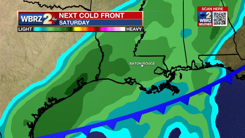
By the weekend, the upper level ridge will move east and the next frontal system will slowly drop into the area from the northwest. The front will bring showers and thunderstorms into the forecast for Saturday and some could linger Sunday as cooler temperatures arrive to the end of the weekend. CLICK HERE for your detailed 7-Day Forecast.
The Explanation: The warming trend will persist on Wednesday as sinking air associated with an upper level ridge centered over the Southeast U.S. pushes highs toward the 80s. By the end of the week, the ridge will still be firmly in control but likely centered just east of the local area. Positioned on the western side of this ride, deep southerly flow will continue to add moisture into the atmosphere. With more moisture, comes higher dew points and therefore the potential for overnight fog and warmer low temperatures. With a higher starting point, it will be even easier for afternoon temperatures to achieve the 80s on Thursday and Friday. Forecast confidence decreases heading into the weekend. An upper level trough of low pressure will try to break away from the Western U.S. and bring a cold front with it into the region. As the front slows and begins to parallel the Gulf Coast, it is unclear if there will be enough upper level energy to push the front south and through the area. This could delay or even cancel the arrival of much cooler air. Additionally, a slow moving or stalling front could mean the chance for showers stays in the forecast for a few days. Of course, if the front is more progressive, the opposite of each of these scenarios would be true. Things should become clearer by the middle of the week.
--Josh
The WBRZ Weather Team is here for you, on every platform. Your weather updates can be found on News 2, wbrz.com, and the WBRZ WX App on your Apple or Android device. Follow WBRZ Weather on Facebook and Twitter for even more weather updates while you are on the go.
News
