

Latest Weather Blog
Tuesday evening video forecast
Related Story
There are two named storms in the Atlantic Basin, but neither poses a threat to our area. Heat will be a growing story into the weekend.
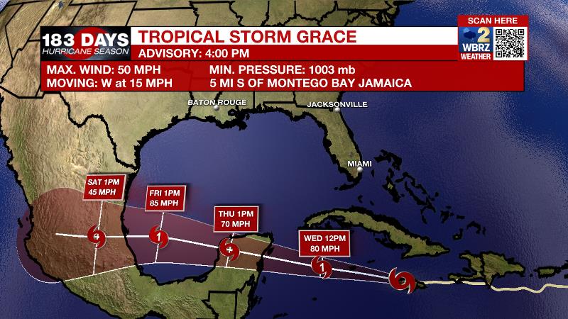
The Tropics: As of 4pm Tuesday, Tropical Storm Grace was near the northwest coast of Jamaica with maximum sustained winds at 50mph and moving to the west-northwest at 15mph. This general motion or a more due west track will occur over the next few days as Grace strengthens into a hurricane by Wednesday night. Hurricane Warnings have been posted for the Yucatan Peninsula. Grace will remain well south of the central Gulf Coast, crossing the southern Gulf of Mexico and reach central Mexico over the weekend.
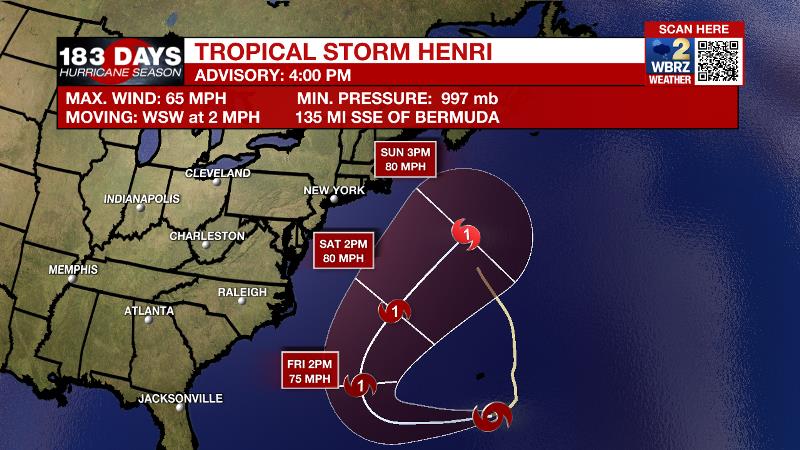
As of 4pm Tuesday, Tropical Storm Henri was getting better organized southeast of Bermuda with maximum sustained winds of 65mph and a west-southwest motion at 2mph. Henri will speed up while circling south and then east of Bermuda as a hurricane. While the eastern U.S. may need to monitor Henri for some high surf, this system will not impact the Gulf Coast.
The remnants of Tropical Storm Fred produced tornadoes and flash flooding across the Appalachian Mountains and Carolinas on Tuesday. The system will continue moving northeast through Wednesday.
For the latest tropical forecasts, advisories and information, visit the WBRZ Hurricane Center as we navigate all 183 Days of Hurricane Season.
Next 24 Hours: Any leftover showers will diminish by midnight. Low temperatures will stop around 74 degrees. As has been the case of late, and unsurprisingly, Wednesday will begin on a mostly sunny note. High temperatures will reach 92 degrees by 3pm. Around this time, clouds will increase and scattered showers and thunderstorms will develop and linger into the evening.
Up Next: Thursday will continue the chance for scattered showers and thunderstorms before a change comes. An upper level ridge of high pressure will build over the central Gulf Coast Friday and Saturday. This system will shield the local area from Tropical Storm Grace, but also cause slightly drier and warmer weather. Through Monday, rain coverage in the 13 Parish, 3 County Forecast Area will stay at 20 percent or less and high temperatures will reach the mid 90s with feels-like temperatures over 105 degrees. Lows will stay in the mid to upper 70s. Another round of HEAT ADVISOIRES may be needed. CLICK HERE for your full 7-Day Forecast.
The Explanation: Typical August weather is expected through Thursday. Onshore flow from the Gulf of Mexico will keep warm, humid air over the area with above average moisture for the time of year injected through the atmosphere. In response to destabilization from daytime warming, scattered showers and thunderstorms will develop after high temperatures reach the low 90s. As you might expect, while severe weather is not anticipated, any thunderstorms will be capable of brief downpours and frequent lightning. Models hint at an uptick in activity for Thursday, possibly tied to a slug of enhanced tropical moisture moving across the Gulf Coast.
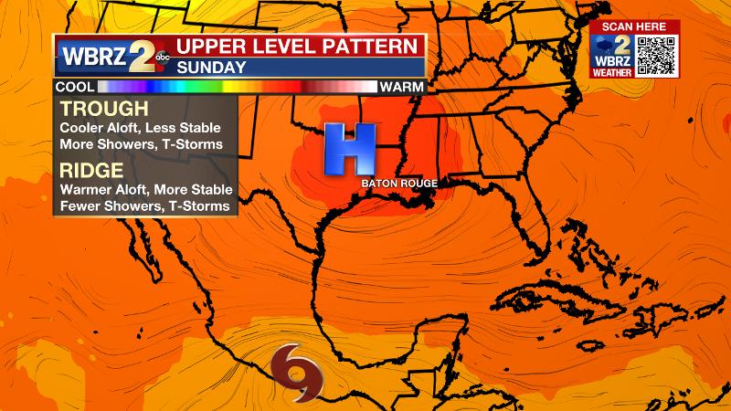
By Friday, an upper level ridge will build across the region. The effects of this ridge will be two-fold. First, and more importantly, the clockwise circulation around the ridge will steer Tropical Storm Grace from east to west across the southern Gulf of Mexico, away from the local area. Therefore, no impacts are expected from that system. Second, the ridge will cause subsidence, or sinking air, will serves to suppress convection and cause even more warming. With humidity not going anywhere, the heat index will have no problem reaching the 105 – 110 range Friday through Monday as air temperatures peak in the mid 90s. This may cause the National Weather Service to issue Heat Advisories once again. Friday and Saturday should feature a rather dry atmosphere and rain will be tough to find. A little bit more moisture may be found in the atmosphere on Sunday and Monday for isolated, afternoon showers and thunderstorms to develop. The bottom line is, it is difficult to guarantee completely dry conditions across the area with all the instability along the Gulf Coast this time of year, but daily rain coverage will be much lower than usual.
--Josh
The WBRZ Weather Team is here for you, on every platform. Your weather updates can be found on News 2, wbrz.com, and the WBRZ WX App on your Apple or Android device. Follow WBRZ Weather on Facebook and Twitter for even more weather updates while you are on the go.
News
