

Latest Weather Blog
Thursday Morning Video Forecast
Related Story
Clouds persist through Friday. To kick off the weekend, a weak cold front will sweep away most of the cloud cover resulting in a beautiful weekend in the boot!
Today & Tonight: Today will be mainly cloudy once again, but later this afternoon we do expect a few breaks of sun. Depending on the amount of sun we see, afternoon temperatures around southern Louisiana will range from the upper 60s to lower 70s. Tonight skies will remain partly cloudy and temperatures will be around 60 degrees for a mild start to Friday.
Up Next: A weak cold front will move through Louisiana Friday night bringing with it plenty of dry air that will help eliminate most of the cloud cover for a little while this weekend. Saturday will begin with some lingering clouds and temperatures in the upper 50s but returning sunshine will help to bump readings back into the mid 70s. Sunday will start off chilly with lows in the mid 40s. Early sun will help take highs into the low 70s before clouds increase ahead of active weather coming in on Monday.
After a fairly quiet Saturday and Sunday, Thanksgiving Week will likely start off with some active weather. It is too early to determine exact timing and potential hazards, so check in with the Storm Station as we get closer. Much cooler air will follow that system. pic.twitter.com/nbbxijWyRK
— Josh Eachus (@DrJoshWX) November 16, 2023
A frontal system will bring scattered showers and thunderstorms to the area as the new week begins. As we head closer to the weekend, details on how much rain, and even the possibility of stronger thunderstorms will come into focus. Either way, be aware that this system could impact one or both commutes on Monday. Much cooler temperatures will push in behind this feature to leave us with below average temperatures for Thanksgiving.
Get the latest 7-day forecast and real time weather updates HERE.
Watch live news HERE.
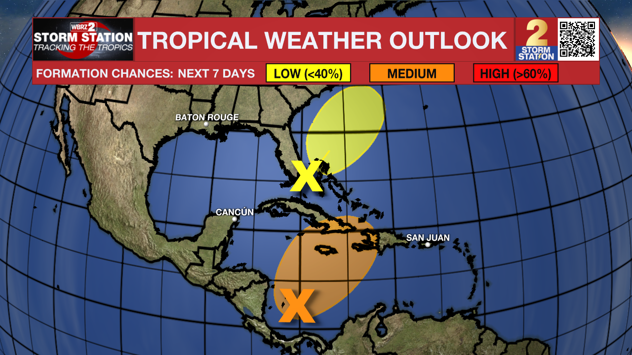
The Tropics: Showers and thunderstorms associated with a broad area of low pressure located over the west-central Caribbean Sea have become a little better organized since yesterday. Environmental conditions appear conducive for some additional development, and a tropical depression could form over the next day or two while the low moves northeastward toward Jamaica, Haiti, and eastern Cuba.
A non-tropical area of low pressure between southern Florida and the northwestern Bahamas is associated with a frontal boundary. Development of this system into a tropical cyclone appears unlikely. However, this system is expected to produce gusty winds and heavy rains across portions of southern Florida, the Florida Keys, and the Bahamas during the next couple of days.
– Emma Kate Cowan
The Storm Station is here for you, on every platform. Your weather updates can be found on News 2, wbrz.com, and the WBRZ WX App on your Apple or Android device. Follow WBRZ Weather on Facebook and Twitter for even more weather updates while you are on the go.
News
