

Latest Weather Blog
Thursday Morning Video Forecast
Related Story
Dry air moving in this weekend squashes rain chances, allows for temperatures to top out near record breaking values, and could heighten fire weather danger for South Louisiana.
Today & Tonight: Mostly to partly sunny skies around south Louisiana today. A passing shower could develop later today although the chance stays unlikely, especially north of I-10/12. High temperatures will be well above average in the mid 90s. Overnight, we will watch temps fall near 70 degrees under mostly clear skies.
Up Next: Friday will bring a nearly identical forecast to Thursday. Some subtle changes are expected to begin the weekend and will last into the middle of next week. Drier air will filter into the atmosphere, essentially eliminating rain chances, keeping skies mainly clear and lowering humidity. As a result, daily temperature ranges will increase with morning lows in the upper 60s and afternoon highs in the mid 90s. Though feels-like temperatures will be in check, those highs will be near records for the time of year. Additionally, low humidity and a breeze near 10mph could bump up the fire weather danger. There are no signs of beneficial rain or cooler temperatures in the Storm Station 7-Day Forecast.
Get the latest 7-day forecast and real time weather updates HERE.
Watch live news HERE.
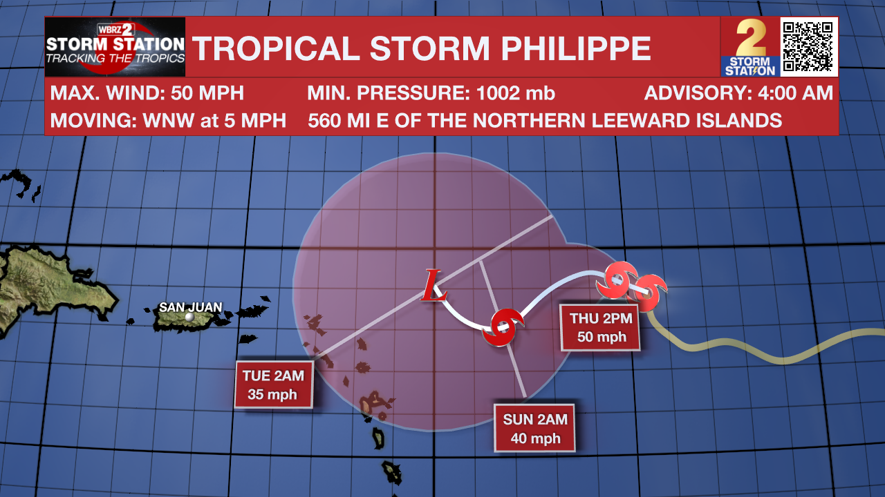
The Tropics: Tropical Storm Philippe is slowing down and holding strength across the central Atlantic Ocean. Interests in the northern Leeward Island, Virgin Islands and Puerto Rico will need to monitor the progress of the system. With maximum sustained winds of 50mph, the storm is gliding west at 5mph. Philippe is expected to maintain strength and continue west-northwest over the next few days, eventually delivering some heavy rain to the islands in its path.
Showers and thunderstorms have changed little in organization in association with an area of low pressure located roughly halfway between the Cabo Verde Islands and the Lesser Antilles. Environmental conditions are forecast to be conducive for development, as long as this system remain far enough away from Tropical Storm Phillipe to its west. A tropical depression or storm is expected to form in the next day or so while the system moves west-northwestward across the central tropical Atlantic.
– Emma Kate Cowan
The Storm Station is here for you, on every platform. Your weather updates can be found on News 2, wbrz.com, and the WBRZ WX App on your Apple or Android device. Follow WBRZ Weather on Facebook and Twitter for even more weather updates while you are on the go.
News
