

Latest Weather Blog
Thursday Evening Video Forecast
Related Story
Several waves of showers and storms are possible through Saturday, bringing locally heavy rain to the region. While there will be some dry time outside both on Friday and Saturday, rain gear may come in handy as we continue to dodge rain. By Sunday and early next week, the capital area will trend much drier.
Tonight & Tomorrow: Showers return to the capital area late Thursday afternoon and evening. This could make for a soggy evening commute, so make sure to have the rain gear handy and prepare for weather-related delays on the drive home. While some of the activity may let up during the evening hours, we’ll still be dodging isolated to widely scattered showers.
Overnight, we’ll be watching a line of storms in central Louisiana. This appears to gradually shift toward the BR metro closer to daybreak, perhaps affecting the morning commute for some. There is an outside chance for one of these storms to be on the stronger side, especially in our southwestern parishes. The overall odds of severe weather are slim, but non-zero. Damaging winds and perhaps an brief spin-up would be the primary concerns.
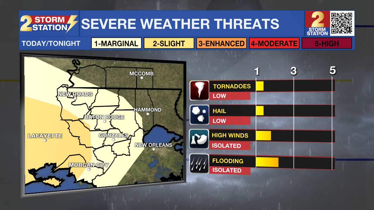
Storm chances dwindle through the morning hours on Friday, with only a spotty shower chance during the afternoon. We might even see some breaks in the cloud coverage. This will help push high temperatures into the upper-70s. Despite a lull in rain coverage during the day, we expect another round of widespread showers and thunderstorms on Friday evening/night. Again, we can’t rule out a strong storm or two with the Friday night's round of storms.
Up Next: We’ll keep cloud cover into Saturday, along with a chance to see a few more isolated storms. If you have any plans on Saturday, know that it will not be a washout. Rain chances fade away on Sunday with clouds hanging around. By the time all things are said and done, it looks like we'll see roughly 2-3" across the area with locally higher amounts. It will be warm over the weekend with highs in the low to mid-70s. For next week, the overall pattern looks dry. We’ll also see a cooldown by midweek.
Get the latest 7-day forecast and real time weather updates HERE.
Watch live news HERE.
The Tropics: No tropical development is expected over the next 7 days. Today is the final day of the Atlantic Hurricane Season.
-- Meteorologist Malcolm Byron
The Storm Station is here for you, on every platform. Your weather updates can be found on News 2, wbrz.com, and the WBRZ WX App on your Apple or Android device. Follow WBRZ Weather on Facebook and Twitter for even more weather updates while you are on the go.
News
