

Latest Weather Blog
Thursday evening video forecast
Related Story
While clouds will be stubborn for a little while longer, a weak cold front will sweep away much of the cloud cover for the weekend. However, a stronger cold front will pass through early next week. This gives us another shot at showers and storms, and some could be strong. Afterward, temperatures will tumble in time for Thanksgiving.
Tonight & Tomorrow: After another cloudy day, we’ll continue to feature clouds on Thursday night. While there may be a few breaks at times, we still expect partly to mostly cloudy skies. Overnight lows will sit near 60. Mostly cloudy skies will remain in place on Friday. Highs should be a touch warmer, likely reaching the low to mid-70s across the capital area. Although we cannot rule out a sprinkle or two, overall rain chances are very slim.
Up Next: Our next cold front passes through on Saturday. This won’t be much of a concern to those going to the LSU game as the front brings no rain. However, it will be successful in eliminating the cloud cover. We’ll turn mostly sunny through the day, and highs will be comfortable in the low to mid-70s. Sunday also looks quiet, with some high clouds returning.
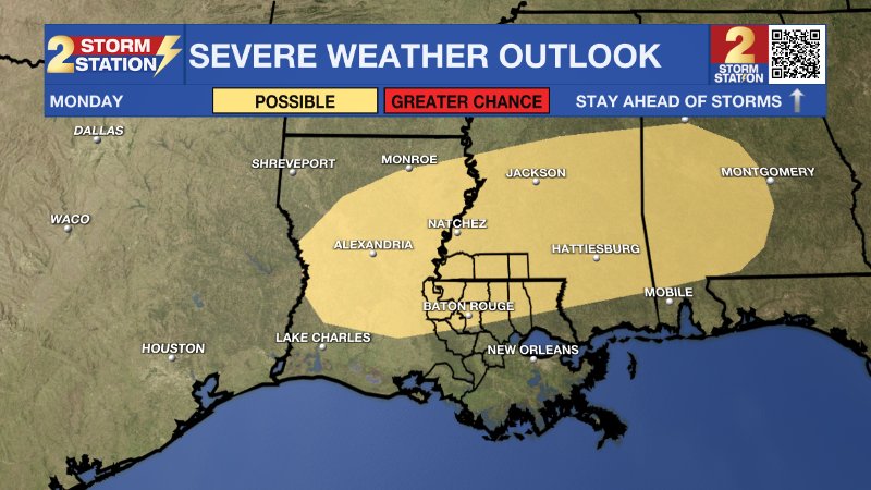
A stronger disturbance is set to arrive on Monday. A warm front will likely pass early in the day, and this feature could trigger a few showers. We’ll warm up a fair amount on Monday afternoon, with thunderstorms not out of the question. Then, a strong cold front will arrive on Monday night. This could produce another round of storms, a few of which could be on the stronger side during the afternoon and evening. We are still working out the details on this system, which will become more clear in the days to follow. Keep up to date with the Storm Station for the latest as new data arrives. Behind the front, temperatures will drop off. This will likely set us up for a much chillier Thanksgiving holiday.
Get the latest 7-day forecast and real time weather updates HERE.
Watch live news HERE.
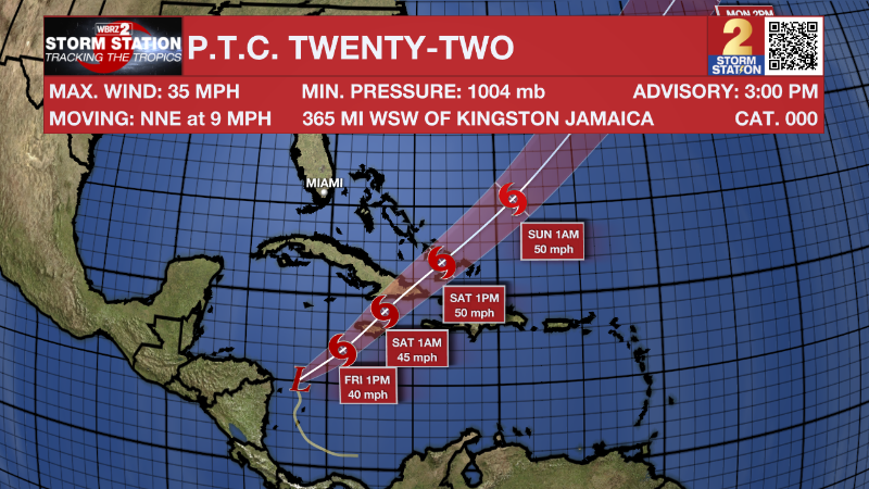
The Tropics: The National Hurricane Center is now issuing forecasts for Potential Tropical Cyclone (P.T.C.) Twenty-Two in the Caribbean. The system has yet to acquire tropical characteristics but will likely do so within the next 48 hours and affect land. By Friday, the storm is forecast to become Tropical Storm Vince as it moves northeast. Tropical Storm Watches are in affect for Jamaica, Haiti, and parts of Cuba along with parts the Bahamas.
-- Meteorologist Malcolm Byron
The Storm Station is here for you, on every platform. Your weather updates can be found on News 2, wbrz.com, and the WBRZ WX App on your Apple or Android device. Follow WBRZ Weather on Facebook and Twitter for even more weather updates while you are on the go.
News
