

Latest Weather Blog
Sunday morning video forecast
Related Story
Extremely dangerous and hot temperatures will be possible today. Isolated showers/thunderstorms will be possible Monday but any relief from the heat will be short lived.
A ***HEAT ADVISORY*** is in effect until 7pm today for the entire WBRZ Viewing Area. Dangerously hot conditions with heat index values up to 112 expected. Extreme heat and humidity will significantly increase the potential for heat related illnesses, particularly for those working or participating in outdoor activities. Drink plenty of fluids, stay in an air-conditioned room, stay out of the sun, and check up on relatives and neighbors.
An ***AIR QUALITY ALERT*** is in effect until midnight. The Air Quality Index indicates that ozone will be at the Orange level, which is unhealthy for sensitive groups. Increasing ozone levels may cause unhealthy air quality during afternoon hours. Active children and adults, the elderly, and people with respiratory diseases such as asthma should avoid prolonged outdoor exertion.
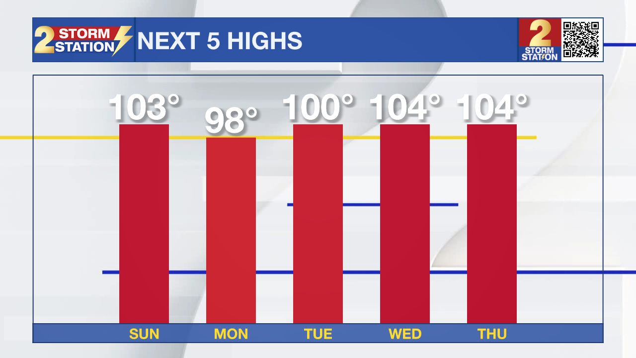
Today and Tonight: Temperatures are going to climb all the way to around 103 degrees this afternoon and evening under partly sunny skies. Humidity will stay high, as feels like temperatures could reach near 112 degrees. A stray shower or two will be possible in the afternoon and evening. Tonight, we will bottom out at a muggy 81 degrees under clear skies.
Up Next:. On Monday, isolated to spotty showers will be possible across a majority of the viewing area, but coastal areas could have the best shot at rain. By the middle of the week, potentially record breaking temperatures could return. We could top out around 104 degrees or higher for multiple days in a row!
Get the latest 7-day forecast and real time weather updates HERE.
Watch live news HERE.
The Tropics:
1. Eastern Tropical Atlantic (AL98): Shower and thunderstorm activity continues to become better organized in association with a broad area of low pressure located several hundred miles west of the Cabo Verde Islands. Environmental conditions appear generally favorable for further development, and a short-lived tropical depression is likely to form within the next day or so while it moves west-northwestward or northwestward at about 10 mph across the eastern tropical Atlantic. By early next week, upper-level winds over the system are forecast to increase, and further development is not expected.
2. *Tropical Depression 6*: A tropical depression has recently formed in the south-central Atlantic. This depression will be short lived and is no threat to the United States.
3. Near the Windward Islands (AL90): Shower and thunderstorm activity continues in association with an area of low pressure near the Windward Islands. Some additional development of this system is likely and a tropical depression could form by early next week while this system moves westward to west-northwestward at 10 to 15 mph over the eastern and central Caribbean Sea. Regardless of development, heavy rainfall is possible over portions of the Windward Islands during the next couple of days. Interests in the eastern and central Caribbean should monitor the progress of this system.
4. Western Gulf of Mexico: Western Gulf of Mexico: An area of disturbed weather located over the Florida peninsula is expected to move into the Gulf of Mexico by early next week, where a broad area of low pressure is expected to form. Some slow development of this system is possible thereafter, and a tropical depression could form as it moves westward and approaches the western Gulf of Mexico coastline by the middle of next week.
5. Near the coast of Africa: A tropical wave located near the western coast of Africa is producing a large area of disorganized showers and thunderstorms. Some slow development is possible while it moves generally west-northwestward across the tropical eastern Atlantic during the next several days.
--Balin
The Storm Station is here for you, on every platform. Your weather updates can be found on News 2, wbrz.com, and the WBRZ WX App on your Apple or Android device. Follow WBRZ Weather on Facebook and Twitter for even more weather updates while you are on the go.
News
