

Latest Weather Blog
Sunday Evening Video Forecast
Related Story
After a pleasant weekend, a strong storm system could make things not so pleasant to start to the week. Showers and thunderstorms will be possible on Monday, especially during the evening hours. A few storms could be on the strong to severe side.
Tonight & Tomorrow: A few clouds will be with us overnight and into Monday morning. It’ll be a quiet night, with an overnight low in the mid-50s. A warm front will lift through the capital area early Monday morning. Temperatures will respond by warming into the upper-70s and perhaps close to 80° by afternoon. At times, you may run across a spotty shower during the daytime hours. That said, rain chances during the day are actually fairly low. That changes during the evening.
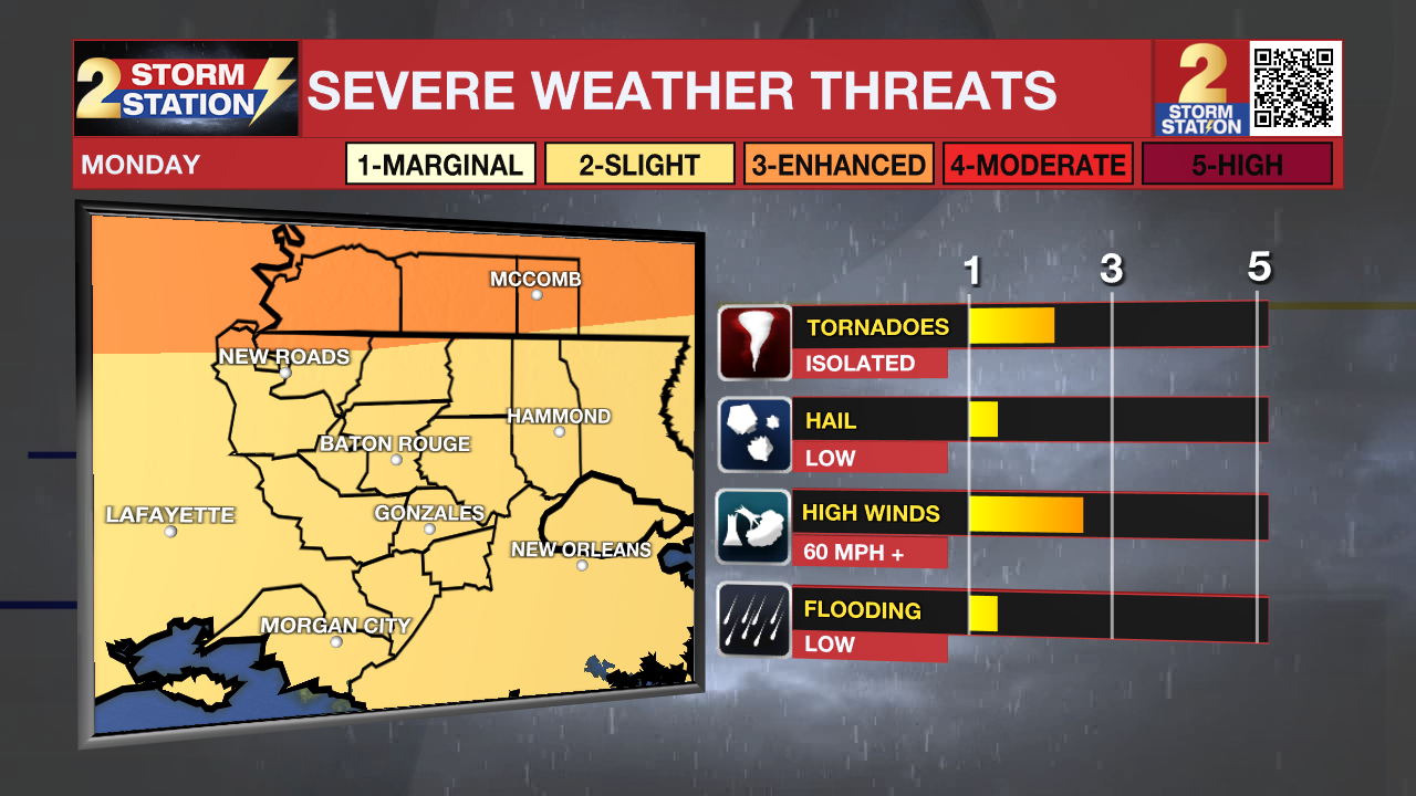
A trailing cold front bring storms through the region on Monday night. This will be the metro area’s best opportunity to see storms, a few of which could be on the strong to severe side. The Storm Prediction Center has placed our Mississippi counties under a Level 3/5 risk for severe weather, where scattered severe storms are possible. We’ll likely see less severe weather to the south. Nevertheless, Baton Rouge is under a Level 2/5 severe risk, where isolated instances of severe weather are possible. Wind seems to be the primary concern, although we can’t rule out isolated tornadoes.
Timing is still a bit questionable, but we could see storms as early as the 5-6 p.m. timeframe. However, I would not be surprised if the onset time was delayed by several hours, closer to the 9-11 p.m. timeframe. Either way, this looks like a Monday evening issue. This is an opportunity for some beneficial rain also. A quick 1-2” will be possible with the evening and overnight storms.
Stay tuned to the Storm Station over the day or so as we get closer to the event. We be with you on-air and online from start to finish. In the meantime, now is a good time to review your severe weather safety plan in case severe weather strikes your community.
Up Next: Storms depart the region overnight Monday. We will turn drier by daybreak Tuesday. Clouds will stick around for the rest of the day, and it will be significantly cooler. This trend will hold for the rest of the week. In fact, we will be watching another disturbance by Thanksgiving which could bring some rain to southern Louisiana. It’s still several days out, but we’ve had bump up rain chances in the meantime for Thanksgiving.
Get the latest 7-day forecast and real time weather updates HERE.
Watch live news HERE.
The Tropics: A small area of low pressure in the central Caribbean Sea has a slim chance of developing into a tropical system over the next few days. While we will watch it closely, environmental conditions do not favor any major development.
-- Meteorologist Malcolm Byron
The Storm Station is here for you, on every platform. Your weather updates can be found on News 2, wbrz.com, and the WBRZ WX App on your Apple or Android device. Follow WBRZ Weather on Facebook and Twitter for even more weather updates while you are on the go.
News
