

Latest Weather Blog
Monday Morning Video Forecast
Related Story
A strong storm system will move through the state later today bringing the chance for severe weather to southern Louisiana for the first time in a while. Make sure to know your severe weather safety plans, turn on weather alerts, and download the Storm Station app to stay up to date on severe weather information.
Today & Tomorrow: A warm front slides through the state early this morning which will be reflected by temperatures climbing close to 80° this afternoon. Spotty showers will be around during daytime hours however, rain chances during the day remain fairly low. A much different story will playout beginning in the early evening hours. Timing as of now has the best chance to see stronger storms beginning around 5-6pm; which could impact your evening commute home.
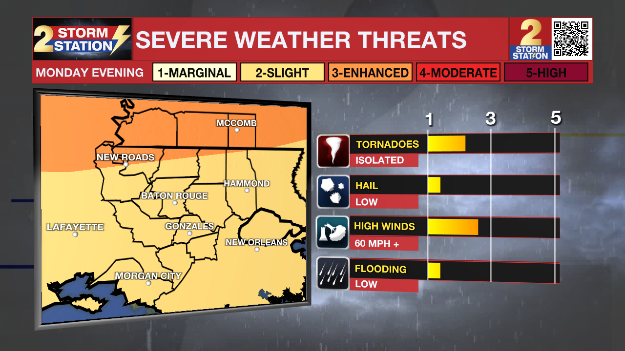
A trailing cold front brings storms to SE Louisiana tonight. This will be the metro area’s best opportunity to see storms, a few of which could be on the strong to severe side. The Storm Prediction Center has placed our Mississippi counties under a Level 3/5 risk for severe weather, where scattered severe storms are possible. We’ll likely see less severe weather to the south. Nevertheless, Baton Rouge is under a Level 2/5 severe risk, where isolated instances of severe weather are possible. Wind seems to be the primary concern, although we can’t rule out isolated tornadoes.
This system also brings an opportunity for some beneficial rain. A quick 1-2” will be possible with the evening and overnight storms.
The Storm Station will be with you on-air and online from start to finish, sharing the latest information you need to know about this storm system.
Up Next: By Tuesday morning, we will dry out and clouds will stick around for the rest of the day. Thanks to the cold front, we will begin seeing cooler temperatures around the state. The below average temperatures stick around all week with Thanksgiving being the coolest day over the next 7. Your turkey day could also be a bit soggy. We are watching another disturbance that could bring some rain to southern Louisiana on Thursday.
Get the latest 7-day forecast and real time weather updates HERE.
Watch live news HERE.
The Tropics: A small area of low pressure in the central Caribbean Sea has a slim chance of developing into a tropical system over the next few days. While we will watch it closely, environmental conditions do not favor any major development.
-- Emma Kate Cowan
The Storm Station is here for you, on every platform. Your weather updates can be found on News 2, wbrz.com, and the WBRZ WX App on your Apple or Android device. Follow WBRZ Weather on Facebook and Twitter for even more weather updates while you are on the go.
News
