

Latest Weather Blog
Monday Morning Video Forecast
Related Story
Patches of dense fog are possible for the Monday morning commute. Any fog that does develop will burn off by late morning, setting us up for a sunnier afternoon. We’ll also be very warm, with highs running roughly 10° above average. For that matter, we don’t see too many day-to-day changes in the forecast.
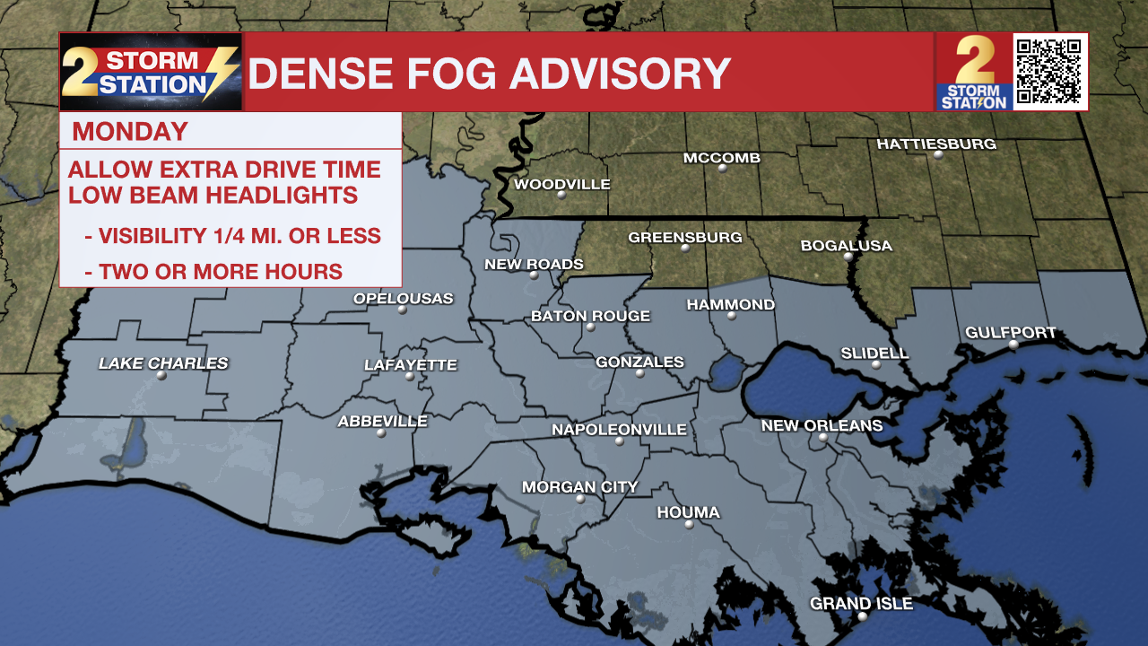
Today & Tonight: A Dense Fog Advisory is in effect across southern Louisiana through 10 a.m. Monday, including the BR metro area. Visibilities below 1/4-mile are possible in the gray-shaded parishes. Be sure to leave early to give yourself a few extra minutes for your commute and take it slower in areas of fog.
Any fog will burn off by late morning, and skies will eventually turn mostly sunny. That will help push temperatures into the upper-80s for highs. This is roughly 10° above the average for late October.
Up Next: There aren’t too many day-to-day variations in the Storm Station 7-Day Forecast. High temperatures will continue to be in the upper-80s through the rest of the week. Rain chances are limited also. We do include a 10% chance of rain by midweek as there might be just enough moisture for a pop-up shower. However, this will not be a drought-busting rain, nor will many actually observe it.
The upper-air pattern features a ridge of high pressure, which tends to produce warm and dry weather. Until that breaks down, the forecast doesn’t change all too much.
Get the latest 7-day forecast and real time weather updates HERE.
Watch live news HERE.
The Tropics: Hurricane Tammy remains the only active tropical system as of Monday morning with maximum sustained winds at 80 mph. The storm is moving north, away from the Lesser Antilles. There are some question marks as to where Tammy goes in the long-term. However, the general trend will be for the storm to weaken and become post-tropical by this weekend as the storm moves into cooler waters.

We are also watching another tropical wave showing signs of organization in the southwest Caribbean Sea. The system has shown some signs of organization recently, and may become a short-lived tropical depression before moving inland over Nicaragua in central America early Tuesday.
-- Meteorologist Malcolm Byron
The Storm Station is here for you, on every platform. Your weather updates can be found on News 2, wbrz.com, and the WBRZ WX App on your Apple or Android device. Follow WBRZ Weather on Facebook and Twitter for even more weather updates while you are on the go.
News
